Boating the Upper Chesapeake

SuperNova

Lieutenant
Joined
Mar 16, 2007
Messages
1,455
Re: Boating the Upper Chesapeake

I made reservations at Duck Neck Campground in Chestertown for the weekend of July 4th. We booked a waterfront campsite (Chester River) where they say they have a dock or you can just anchor out in front of the campsite. We plan to watch the fireworks show in Chestertown from the water. Does anyone have any input of the campground, the fireworks show in Chestertown or boating on the Chester River? We've never been to any of them..
I don't know about the campgrounds, but I can tell you the Chester is salt water and has LOTS of jellyfish.....and crabs....mmm
 

skargo

Banned
Joined
Sep 14, 2008
Messages
4,640
Re: Boating the Upper Chesapeake

I don't know about the campgrounds, but I can tell you the Chester is salt water and has LOTS of jellyfish.....and crabs....mmm

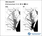
Shouldn't have any issues with salt and jellies this time of year though, right?
 

Attachments

  • temp.jpg
    temp.jpg
    16.7 KB · Views: 0

Damifudo

Petty Officer 1st Class
Joined
Sep 14, 2009
Messages
277
Re: Boating the Upper Chesapeake

There will be a group of us rafted up at Hartmiller island Monday around noon. I think we will be lauching from rocky point park. Its going to be a beautiful day. Stop by and say hello you cant miss the red boat.
 

skargo

Banned
Joined
Sep 14, 2008
Messages
4,640
Re: Boating the Upper Chesapeake

We'll be rafted up at Cara(imagine that) if anyone is up North. Can't wait!
 

bowman316

Lieutenant Commander
Joined
Oct 21, 2008
Messages
1,822
Re: Boating the Upper Chesapeake

i went out sunday night around 6, and anchored up near the side channel over to the ne river.
right near perry point.
stayed there till about midnight
 

skargo

Banned
Joined
Sep 14, 2008
Messages
4,640
Re: Boating the Upper Chesapeake

Where was everyone today? We had a great time on the water today.

27809_1334610645683_1243580722_30897764_3254805_n.jpg
 

SuperNova

Lieutenant
Joined
Mar 16, 2007
Messages
1,455
Re: Boating the Upper Chesapeake

Shouldn't have any issues with salt and jellies this time of year though, right?
Probably not right now, but by the Fourth of July there will be a huge issue with them. Since that is when they are asking about, that is the info I gave them.:) By the fourth, the Chester, Wye and Tred Avon will all be swarming with jellyfish. I know, because I have to deal with them all over the trautline and the pots. My hands pay for my crabs..lol
 

bowman316

Lieutenant Commander
Joined
Oct 21, 2008
Messages
1,822
Re: Boating the Upper Chesapeake

i second that. Every time I go trot lining in the wye river, they are all over the line.
 

rauch0812

Petty Officer 2nd Class
Joined
Feb 4, 2010
Messages
145
Re: Boating the Upper Chesapeake

Oh boy. That bad? Hope I didn't make a mistake by booking down there then. If someone gets stung I know my kids - they'll be afraid to go back in the water. Is it so bad you can't tube?
 

skargo

Banned
Joined
Sep 14, 2008
Messages
4,640
Re: Boating the Upper Chesapeake

Probably not right now, but by the Fourth of July there will be a huge issue with them. Since that is when they are asking about, that is the info I gave them.:) By the fourth, the Chester, Wye and Tred Avon will all be swarming with jellyfish. I know, because I have to deal with them all over the trautline and the pots. My hands pay for my crabs..lol
I missed the 4th part, sorry! :redface:

Jellies suck!

*edit*
Looking at a map of the campground, it is way up the river by Chestertown, hopefully Jellies aren't an issue that far up.
Here's a forecast map.
http://chesapeakebay.noaa.gov/forecasting-sea-nettles//
 

bowman316

Lieutenant Commander
Joined
Oct 21, 2008
Messages
1,822
Re: Boating the Upper Chesapeake

you can probally find a spot where there are no jellys
 

coolbikeguy

Chief Petty Officer
Joined
May 14, 2009
Messages
491
Re: Lower Susquehanna

Re: Lower Susquehanna

ok bay/c and d experts ... have a question. its been a long LONG time sine ive done this but, i want to put in at tydings park and then head over to the c/d canal and head into ches.city. when i leave tydings i pretty much go sraight out from there and maybe slightly south right ? across the flats or not ? my buddy and i want to do this on jet skis so is there anything we need to worry about?? ive done this years ago but a reminder from you guys that are out there all the time would be nice. thanks guys, scott
 

skargo

Banned
Joined
Sep 14, 2008
Messages
4,640
Re: Lower Susquehanna

Re: Lower Susquehanna

ok bay/c and d experts ... have a question. its been a long LONG time sine ive done this but, i want to put in at tydings park and then head over to the c/d canal and head into ches.city. when i leave tydings i pretty much go sraight out from there and maybe slightly south right ? across the flats or not ? my buddy and i want to do this on jet skis so is there anything we need to worry about?? ive done this years ago but a reminder from you guys that are out there all the time would be nice. thanks guys, scott

I guess you can go across the flats on jetskis, but not in a boat. You need to go around Turkey Point and up the Elk.
Do you have charts?
 

coolbikeguy

Chief Petty Officer
Joined
May 14, 2009
Messages
491
Re: Boating the Upper Chesapeake

no charts yet as this is just an idea we have. where can i get charts of the area. i used to be all over that area in a small alu. boat and jet ski, off perry point, the flats, turkey point, sassaras, but id be a little leary these days since its been so long. thanks for the help
 

rauch0812

Petty Officer 2nd Class
Joined
Feb 4, 2010
Messages
145
Re: Boating the Upper Chesapeake

Chart -
Here's the chart someone shared earlier in this thread that covers the area:
http://www.charts.noaa.gov/OnLineViewer/12274.shtml

Jellies -
Thanks for the link, I'll start using it! I also finally learned what nettles are... lol. I've heard you guys talk about "nettles" in the thread before and just thought 'I just care about jellies - not worried about nettles'. Ha Ha. I'm a born and raised California girl who was dragged out East... we didn't have Jellies (or Nettles)! :D
 

rauch0812

Petty Officer 2nd Class
Joined
Feb 4, 2010
Messages
145
Re: Boating the Upper Chesapeake

Another question... I know this outside the Chesapeake, but since we've never left the Chesapeake...

We we're invited to meet some friends for fireworks in Delaware's Battery Park on June 12th for Separation Day. Our boat is currently on the Bohemia. Is it too much of a haul to go from the Bohemia up thru the Canal to Delaware Bay then up to Battery Park?

Our friends have said they will meet us on the Delaware side of the canal. All we've done is go between the Sassafrass and the Bohemia and we're comfortable with that unless the waves get high - then we hide back in a river. We have a 20' Larson 206Lxi Bow Rider with a 5.0 I/O and a 37 gal tank... would we be good on gas? Is this over our heads?
 

bowman316

Lieutenant Commander
Joined
Oct 21, 2008
Messages
1,822
Re: Boating the Upper Chesapeake

well the canal it self is 14 miles long. And it may be a 10-15 mile trip to get the the canal. so easily 35 miles one way. Then are you going to stop near the end of the canal?
how many mpg do you get?
i would plan on stopping and refuling at a marina. find a place in the delaware bay to get gas.
 

Billdc

Petty Officer 1st Class
Joined
Oct 13, 2008
Messages
270
Re: Boating the Upper Chesapeake

Another question... I know this outside the Chesapeake, but since we've never left the Chesapeake...

We we're invited to meet some friends for fireworks in Delaware's Battery Park on June 12th for Separation Day. Our boat is currently on the Bohemia. Is it too much of a haul to go from the Bohemia up thru the Canal to Delaware Bay then up to Battery Park?

Our friends have said they will meet us on the Delaware side of the canal. All we've done is go between the Sassafrass and the Bohemia and we're comfortable with that unless the waves get high - then we hide back in a river. We have a 20' Larson 206Lxi Bow Rider with a 5.0 I/O and a 37 gal tank... would we be good on gas? Is this over our heads?

There is a marina/fuel on the Del. City canal that you could hit on the way up and should be fine for the ride home(could be something even closer to the park). What did your friends say about the Delaware? I've heard something about afternoon wind and tide chages blowing up a nasty chop, but that is second hand news. But the canal itself has been nice the few times I've been there, and I think our boats are pretty similar in size and ride. I would bet it's going to be a 90 min. ride at cruising speed. Something to think about after the fireworks.
 

bowman316

Lieutenant Commander
Joined
Oct 21, 2008
Messages
1,822
Re: Boating the Upper Chesapeake

the delaware bay is so open to the altantic, it is basically the ocean.
it makes a v to the ocean, with the point of the v being at the canal.
 

arks

Lieutenant Commander
Joined
Nov 7, 2002
Messages
1,929
Re: Boating the Upper Chesapeake

Yeah, both BillDC and Bowman are correct- due to its relatively shallow depth and conical shape, a breeze from the south can whip the Delaware bay into a very nasty chop- particularly during an ebb tide (flowing out). Even big cruisers are uncomfortable in those conditions. That chop can travel all the way up into the river around Philly.
IMO with planning a 20 footer can do the trip, but any prudent mariner will have contigency plans if the weather doesn't cooperate.
Some tips:
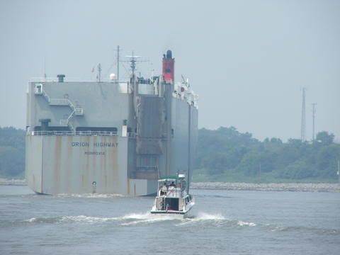
- On the canal, be careful of the commercial ships. They cannot easily turn and have limited visibilty- especially if a small boat is close. ALWAYS give 'em a wide berth and stay out of their way. They can move surprisingly fast. See image below!
- Bowrider- have a canvas bow cover and USE IT if the bow is getting wet.
- Early-to-mid morning hours typically have less breeze, and therefore less chop.
-Time each part of the trip to correspond with the flowing tide- especially east of the C and D.
- Give the breakwaters at the eastern end of the C and D plenty of room- they are often submerged at high tide and go pretty far out. Many small boats have been damaged. Go STRAIGHT out until you're near the marked shipping channel of the Delaware and you'll be A-OK.
- Figure out your fuel range and be extra conservative. For example, if your calculated range is 100 miles then fill up at 50. Some stops enroute: Elk River- Harbor North Marina. C and D canal- Summit North Marina. Delaware Bay North- Delaware City Marina.
- Carry a paper chart in addition to the GPS, depth sounder and VHF radio you SHOULD already have. If you don't have all three, RECONSIDER THE TRIP.
- Have foul weather gear onboard even if the weather forecast is good.
- Don't try to come home in the dark. IMO that's a recipe for disaster. Plan ahead to stay somewhere and wait until morning to shove off for home.

Bottom line- always be safe. Good luck!

Here's a shot of my 34 foot Silverton approaching a ship just east of the C and D. Hard to believe how big those ships are!
winterdream_shipcanal.jpg
 
Top