Michigan to chicago trip help!

jserb

Chief Petty Officer
Joined
Nov 29, 2005
Messages
406
Re: Michigan to chicago trip help!

I couldn't agree more. If you aren't comfortable navigating using a chart, compass, and timepiece I would suggest you not make this crossing in one shot. Assume your GPS will fail. You cannot count on it as a primary navigational tool. Even with GPS you should be plotting your position on the paper chart every 15min. This way if you have an electronics failure you can easily dead reckon your way across with a fair degree of accuracy. The approach into Chicago can be VERY confusing. The ability to confidently read a chart is a necessity for this trip. I would not venture out at night on the Chicago waterfront unless you have someone with you who has made the approach at night before or you are very confident in your abilities. The background lights of the city make picking out nav aids very challenging. Several boats every year run up on the various breakwall rocks on that waterfront. Don't be one of them. Inspect your boat and bring tools and spares. I've made some crazy repairs offshore over the years and while they're fun to talk about now, they weren't real fun when it was looking like our number was up.

You also need a firm grasp on Inland Waterway/COLREGs and if you will be out at night you need to understand navigational lighting. If you can't tell how to identify things such as a tug with tow by lights alone you shouldn't be out there at night. Good way to get killed. I came on deck at night during a Mackinac race to find that the helmsman on watch had us set to pass in between a tug with tow separated by about 1000ft of cable. That could have easily been curtains for all 8 of us.The traffic around Lower Huron, Detroit, Erie is kiddie play time compared to this section of water.

14927, 14928, 14930, and 14901 are the charts you need. Your compass (which hopefully is high quality) will be a few degrees off over there (assuming you calibrated it for your local pond.) Make sure you understand and know how to account for magnetic deviation. You will quickly leave cell phone range. Make sure your VHF is working properly and you understand how to properly communicate on it. You should know how to properly hail bridge/lock operators and other vessels. You should know the difference between Securite, Pan Pan, and Mayday and when to use each. The CG wants Lat/Lon, degrees, and speed in knots, # of persons on board and # and type of flotation.. They don't want "Um, I'm in a white boat doin' 30mph headin' toward that orange building." Review your required safety equipment and make sure all of it is up to date. Go over all of your light/sound/flotation/safety and make sure it meets current regs and nothing is expired. You will be a target for law enforcement sporting MI tags. Since you have a friend with Harbor Master duties you can lean on that person for tips on how to deal with the nightmare that is Westrec. They should be able to fill you in on all the details you'll need to know about Chicago harbor system.


If this all sounds like overkill then you've never been in the middle of one of these ponds with the S*&% hitting the fan.


Whoaaaaaa,
someone had their coffee way strong.......

THANKFULLY I am an avid boater, during the winter months i enjoy reading and learning more about boating. Because of this, i know how to use a chart and dead reckon, i understand all nav aids and buoys, I know how to use a compass and the sun for reference, i also know what lights to look for while underway at night. None of the above will be an issue

Regarding the magnetic variation, yes all charts tell the user how to compensate for this. To say its necessary to check a paper chart every 15 mins on this kind of trip is overkill.
Factors that need to be considered, 1. the trip will not be taken at night or during a storm, 2. 20 miles off the coast of Michigan you can see Chicago. 3, as long as you are heading West you will find Chicago.

I appreciate all input, however lets be honest and call this what it is. Personaly, sounds like your trying to mislead and scare a highly educated boater. I find sometimes on these threads people give negative advice and at times try to hinder the objectives of another boater.
 

Shife

Chief Petty Officer
Joined
Oct 22, 2009
Messages
404
Re: Michigan to chicago trip help!

Whoaaaaaa,
someone had their coffee way strong.......

THANKFULLY I am an avid boater, during the winter months i enjoy reading and learning more about boating. Because of this, i know how to use a chart and dead reckon, i understand all nav aids and buoys, I know how to use a compass and the sun for reference, i also know what lights to look for while underway at night. None of the above will be an issue

Regarding the magnetic variation, yes all charts tell the user how to compensate for this. To say its necessary to check a paper chart every 15 mins on this kind of trip is overkill.
Factors that need to be considered, 1. the trip will not be taken at night or during a storm, 2. 20 miles off the coast of Michigan you can see Chicago. 3, as long as you are heading West you will find Chicago.

I appreciate all input, however lets be honest and call this what it is. Personaly, sounds like your trying to mislead and scare a highly educated boater. I find sometimes on these threads people give negative advice and at times try to hinder the objectives of another boater.

So you're going to cancel your trip if the weather isn't 100% perfect? There are days when you can't see the Chicago skyline 5 miles from Chicago due to atmospheric haze.

I'm not trying to scare or mislead anyone. But I have done this trip more than once and I spend days at a time, sometimes doublehanded, on the Great Lakes.

What's your contingency plan for being dead in the water at 42*00N 87*05W? Does your VHF have enough range to get you out of that situation? Did you tune your antenna using a standing wave meter?

You're going to do whatever you want. I've met plenty of lifelong novice boaters on the GL's who never progress past even the most basic skills yet think they have it all figured out. I don't know you or how knowledgeable you really are and I haven't charged you for any post I've made, so do with it what you will.

A couple of red flags that suggest to me that you are no more experienced than any other weekend warrior on the GL's:

1. Unsure of how to contact the lock operator.

2. Scoffing at the idea of plotting a position on a paper chart at 15min intervals on an unfamiliar crossing. Do you really think you will be able to give the CG your position in an emergency with the GPS down if you haven't been plotting it?
 

jserb

Chief Petty Officer
Joined
Nov 29, 2005
Messages
406
Re: Michigan to chicago trip help!

Yeah, I knew you wouldn?t just admit it and let it be......

As far as your "assumptions" I am fully aware on how to contact the locks via VHF, and signal for that matter, however in preparing for this trip there was great debate over if the locks would even be open or not due to Asian Carp, thus I was unaware if the locks would be operational when I go. Also, I was not sure if the locks would open for recreational boaters, thus I put this post asking if people in the area or people who have done this trip had gone through the locks (as a recreational boat) not as a commercial vessel. I was getting other captains inputs - You know just BEING PREPARED...

Regarding the Charts, no it is overkill...end of story. Coming from a family of airforce pilots your GPS is your life line. And in a plane if that fails, you resort to your back up(and guess what, that back up never seems to fail), on a boat your back up is your compass. In the age of 2010 the odds of your GPS failing are very low; it would be arrogant and irresponsible for me to say that it will never fail, so i am not saying that. However, our troops live off it, our planes live off it, our ships live off it, and failure to the GPS system is a rarity/NOT TO MENTION the odds of the GPS system failing June 24th at 730 AM for me and my crew?.. (lets not get into the possibility of the unit blowing off the boat, a battery dead, or a fire on board, we can argue for days on this??.. just accept that GPS is an extremely dependable system). With all that said, I would not go on a trip without a backup of some sort. My compass is my backup, and as long as I am headed West I will find Chicago(meaning I will find land, and then follow the coats north till I reach the city). To say check the chart every 15 mins in a 30' scarab CC while underway is doing more harm than good, by the time you stop the vessel, check where you are, get under way, stop, check, get under way, you will have easily added 30 to 45 mins to your trip time, and guess what, in 30 for 45mins Lake Michigan could have already picked up?.. only in the end increasing your chance for something to go wrong.

As for the Coast Guard comment, Look at it from this boating trip perspective. We are leaving from St, Joe's where the coast guard station is. IF we are in trouble, we simply read off the coordinates on the GPS, and call for help (no chart required) they come get us end of story. IF THE GPS IS DEAD, we read off the last known coordinates and explain our current compass heading, along with our intended destination?.it is a lake you know, and it just so happens to be a 60 mile area of search zone thy would need to search. ?..(did you know in a plane you can see end to end on Lake Michigan?!?) In an emergency the coast guard will take this information we ramble off to them and they will estimate with local currents where we are most likely to be..... All of this coupled with my flairs, and bright flotation devices, they should have no problem finding us. ?IF MY GPS DIES, AND I CANT RADIO FOR HELP, GUESS WHAT! THE CHART IS AT THE BOTTOM OF THE SEA, NOT HELPING ME, and I just spent all trip stopping and going to read the chart so that when the coastguard comes and finds me I?ll be able to tell them ?well I knew I was at NW3356957886, the entire time! Point is, I have reviewed the chart prior to the trip. For this particular boat trip, and scenario, no one can disagree with the fact that stopping to check a chart will not be the deciding factor in us having a safe trip. There are far larger fish to fry??We are not leaving in a storm, we are not leaving in Fog, and we are not leaving at night.
Don?t worry though, Ill post photos of the trip for you, be sure to wait here on the computer while I go be a captain and have a safe fun trip?..
 

Shife

Chief Petty Officer
Joined
Oct 22, 2009
Messages
404
Re: Michigan to chicago trip help!

Typical weekend warrior. Have fun, "Captain".

You do realize that you, as a civilian, are not in any way entitled to access GPS data and that it can be turned off for civilian use at any time right? But by all means rely of a made in Taiwan piece of electonics as your only means of navigation. Paper charts are for old men and nerds anyways. Hard to impress the ladies when you're busy acting responsible...
 

jserb

Chief Petty Officer
Joined
Nov 29, 2005
Messages
406
Re: Michigan to chicago trip help!

Thanks for the response!

Typical weekend warrior. Have fun, "Captain".- No I boat on the weekdays as well?.

You do realize that you, as a civilian, are not in any way entitled to access GPS data and that it can be turned off for civilian use at any time right?- Well lets hope June 25th 2010 at 7:30AM till 9AM its on?if not, the compass will be just fine.

?by all means rely of a made in Taiwan piece of electronics as your only means of navigation.? ? I think a compass is a means of navigation?.about 500 years ago a guy named Columbus solely relied on this one instrument?.he did fairly well, turns out the earth isn?t flat after all!

?Paper charts are for old men and nerds anyways.?- Naaa, they?re for boaters; you?re the nerd

?Hard to impress the ladies when you're busy acting responsible..?- Sounds like this is a common problem for ya?


To clarify for our viewers just so it?s ?on the record?. I LOVE charts, study them and learn from them, and truly appreciate their information. INFACT I have studied the charts of the waters I will be navigating for this trip, and have calculated the magnetic variation I will experience on the lake. My argument is Shife is stating the only way to safely navigate this trip is to check a chart every 15 mins. ? please read what I have posted earlier regarding if a disaster arose how the chart would end up at the bottom of the lake with the GPS and VHF not doing any (MORE) good for me trying to communicate with CG in an emergency.
-To be very clear, I think it is necessary to chart vessel movement while navigating long distances, shallow water, high traffic area?s, and night time navigation.-HOWEVER, FOR MY TRIP on Lake Michigan it is arrogant to say the only safe way to navigate this trip is to stop every 15 mins and check the chart, while at the same time having a gps and compass.
We will be leaving during daylight, will not travel in fog conditions, we draft 2.5ft, we have GPS, compass. We know our compass variation, we know if we head West we will hit land, we know to our south we will hit land, and we know to our stern or East we have land. It is a 60 mile trip, taking 1.5 hrs (can go faster however assuming an average speed at 7:30 AM), we are not leaving if there is a storm on the horizon, we are leaving as early as possible to try to ensure smooth conditions, we are calling family before we leave letting people know we are going out to sea, and lastly all 7 people on board will understand incase of an emergency what I want and need them to do to ensure everyone?s safety- to me that is being a safe prepared captain -just trying to lay out the scenario for all of you to see why I am not bringing a PAPER chart with me on this trip.

Come on guys weigh in?.. weekend warrior inputs are welcome too!
 

Dick Sorensen

Petty Officer 2nd Class
Joined
Feb 5, 2008
Messages
189
Re: Michigan to chicago trip help!

Wow, I've been off line for a few days and came back to see all of this chatter about a run across Lake Michigan! Jserb....man, have you started something....why is that sailors think nothing of going offshore, yet us powerboaters are 'tied' to land....why is that the average guy would generally think nothing about getting in his car and driving 500 miles without a second thought....yet, going across Lake Michigan seems like a death defying venture....I wish I could go with you.....in my 20 foot cuddy 1984 Rinker, which I'm completely confident in. Go get'm.
 

Shife

Chief Petty Officer
Joined
Oct 22, 2009
Messages
404
Re: Michigan to chicago trip help!

Thanks for the response!

Typical weekend warrior. Have fun, "Captain".- No I boat on the weekdays as well?.

You do realize that you, as a civilian, are not in any way entitled to access GPS data and that it can be turned off for civilian use at any time right?- Well lets hope June 25th 2010 at 7:30AM till 9AM its on?if not, the compass will be just fine.

?by all means rely of a made in Taiwan piece of electronics as your only means of navigation.? ? I think a compass is a means of navigation?.about 500 years ago a guy named Columbus solely relied on this one instrument?.he did fairly well, turns out the earth isn?t flat after all!

?Paper charts are for old men and nerds anyways.?- Naaa, they?re for boaters; you?re the nerd

?Hard to impress the ladies when you're busy acting responsible..?- Sounds like this is a common problem for ya?


To clarify for our viewers just so it?s ?on the record?. I LOVE charts, study them and learn from them, and truly appreciate their information. INFACT I have studied the charts of the waters I will be navigating for this trip, and have calculated the magnetic variation I will experience on the lake. My argument is Shife is stating the only way to safely navigate this trip is to check a chart every 15 mins. ? please read what I have posted earlier regarding if a disaster arose how the chart would end up at the bottom of the lake with the GPS and VHF not doing any (MORE) good for me trying to communicate with CG in an emergency.
-To be very clear, I think it is necessary to chart vessel movement while navigating long distances, shallow water, high traffic area?s, and night time navigation.-HOWEVER, FOR MY TRIP on Lake Michigan it is arrogant to say the only safe way to navigate this trip is to stop every 15 mins and check the chart, while at the same time having a gps and compass.
We will be leaving during daylight, will not travel in fog conditions, we draft 2.5ft, we have GPS, compass. We know our compass variation, we know if we head West we will hit land, we know to our south we will hit land, and we know to our stern or East we have land. It is a 60 mile trip, taking 1.5 hrs (can go faster however assuming an average speed at 7:30 AM), we are not leaving if there is a storm on the horizon, we are leaving as early as possible to try to ensure smooth conditions, we are calling family before we leave letting people know we are going out to sea, and lastly all 7 people on board will understand incase of an emergency what I want and need them to do to ensure everyone?s safety- to me that is being a safe prepared captain -just trying to lay out the scenario for all of you to see why I am not bringing a PAPER chart with me on this trip.

Come on guys weigh in?.. weekend warrior inputs are welcome too!
Care to point out where I said the only way to safely make this passage was to plot your position every 15min?

Plotting your position at regular intervals is proper seamanship. Carrying paper charts is proper seamanship.

Even with a PC based chartplotter, a backup Toughbook, backup GPS antenna, backup handheld GPS, etc.. I violate racing rules and will be disqualified if I do not carry the proper charts on most of my offshore races. Why is that I wonder?

Can I ask what the contents of your ditch bag are?
 

Dick Sorensen

Petty Officer 2nd Class
Joined
Feb 5, 2008
Messages
189
Re: Michigan to chicago trip help!

Wow Jserb have you stirred up a hornet's nest. I haven't checked this thread for acouple of days and when I do.....man, you're getting chewed on! Seems like alot of our fellow powerboaters are a little bit afraid of going out of the sight of land! Yet, one could easily drown in 10 inches of water or less! Why is that a guy would think it's nothing to get in his car and drive 500 miles or so without giving a minutes consideration to tires, maps, weather, etc. yet the idea of going across Lake Michigan, what 60 miles?. seems like a death wish.....? come one guys....if you want to be a true waterman then you've got to get experience....not just running outside of the breakwater and then running back at the first sight of 2 foot waves or a squall line....to be a waterman is to be able to handle most situations and then to ride out the other ones you can handle. Seems Jserb has it nailed! If I was available I'd join you and single hand my 20'5" Rinker Cuddy right across that big old lake with you. Grab life by the balls and don't let go!
 

F14CRAZY

Ensign
Joined
Aug 12, 2008
Messages
945
Re: Michigan to chicago trip help!

I've covered some good distance on Lake Michigan and Huron. With some common sense and monitoring of the weather and conditions, jserb doesn't have too much to worry about. I'm still around and so is my 19' Bayliner. jserb's flipping Scarab Sport will be fine in anything short of a gale
 

airdvr1227

Lieutenant Commander
Joined
Jul 15, 2009
Messages
1,666
Re: Michigan to chicago trip help!

Come on guys weigh in?.. weekend warrior inputs are welcome too!

Why bother. You've got it all figured out.
 

jserb

Chief Petty Officer
Joined
Nov 29, 2005
Messages
406
Re: Michigan to chicago trip help!

Ill up date you guys in a few weeks, with trip details, and then after the 27th i will post photos of the trip along with details of my trips log. Stay tuned!
 

J. Howard

Petty Officer 3rd Class
Joined
Jun 9, 2008
Messages
94
Re: Michigan to chicago trip help!

Good luck and have fun on your trip, jserb. I honestly think Shife is just trying to be helpful but I'm going to stay out of it.

I tripped across the lake this past weekend with a big group of guys on a couple of boats (my buddies took their 10-meter Trojan). There was fishing, swimming, and good times. We went to New Buffalo and had dinner and drinks at the Stray Dog and then spent the night at Four Winds Casino -- fun weekend. We almost stayed an extra night in New Buffalo due to some big wave action near shore on Sunday, but we just took it slow in the big waves and it calmed down after a while. We were fully prepared to turn around if it felt dangerous. It wouldn't have broken my heart to have had to spend an extra afternoon at the Stray Dog, though. ;) The Amtrak was an option for getting back to Chicago as well and the Harbor Master offered to let us slip our boat an extra night for free if we decided to do that.

Again, have a good trip and be safe. There is some good info in this thread and I hope it stays around for a while for reference for other boaters who visit Chicago.

Shife, I learned some things from your posts as well so thanks for sharing.
 

F14CRAZY

Ensign
Joined
Aug 12, 2008
Messages
945
Re: Michigan to chicago trip help!

Amtrak is a good option if you start your Chicago trip from Benton Harbor or somewhere along the eastern shore and the conditions get bad
 

JasonCarp

Cadet
Joined
Feb 9, 2009
Messages
16
Re: Michigan to chicago trip help!

The wave height buoy is a bit north of where you are travelling, but this is always helpful before heading out. I run out of Grand Haven and always check it before going. Web cams are great too. Many are trained on the breakwaters and piers and you can judge what the coasts look like at least.

http://www.ndbc.noaa.gov/station_page.php?station=45007

In a 33 Scarab, clear the pier head, point her west and open the throttle!

Enjoy the ride.
 

jserb

Chief Petty Officer
Joined
Nov 29, 2005
Messages
406
Re: Michigan to chicago trip help!

JAson thanks for the tip! I did see this site once before, nice to know a local confirms that its a decent indicator and not an inaccurate reading. Jason, our plan is to hit the water around 730 8 AM. Have you found more often than not the lake is pretty calm at this time?

Heres a general question for all you Lake Michigan boaters....

Here in Lake Erie we get our fair share of rough sea's, however we also see days where literary the lake is like glass and zero wind.....(not common maybe once or twice a season), in fact i sailed out to the Erie islands on a day like this, only 40 miles out, it took us 8.5 hrs due to no wind, basically only current, slowest race iv ever been in.

but my question is does lake Michigan ever lay down like this? At night does she lay down?

Just curious, with all the wind coming out of Chicago I would be surprised if there was a day when the lake was like glass.....but maybe im wrong....
 

J. Howard

Petty Officer 3rd Class
Joined
Jun 9, 2008
Messages
94
Re: Michigan to chicago trip help!

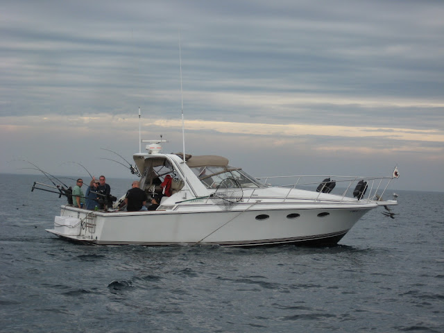
Yes, on very rare occasions, you'll get a real nice flat lake. Very rare. Last weekend when my buddies and I took our boats across, I took some pictures of their boat while they were fishing out in the middle of the lake. Here is one of the pictures, and you can see how calm the lake was:

IMG_0035.jpg


This is probably the calmest that I've ever seen it that far out -- it does happen, but don't hold your breath. ;)
 

JasonCarp

Cadet
Joined
Feb 9, 2009
Messages
16
Re: Michigan to chicago trip help!

It all depends on the weather, This is another good website here. Again, it is somewhat accurate, but use caution. I've seen it flat calm in the middle of the lake in the middle of the day and 4 footers blowing for no apparent reason at first light. I do know the waves this time of year do roll steeper due to the water temp too.

http://www.glerl.noaa.gov/res/glcfs/
 

jserb

Chief Petty Officer
Joined
Nov 29, 2005
Messages
406
Re: Michigan to chicago trip help!

T minus 11 days till the big trip!!!


Start praying for good weather everyone!!
 

TOPGUNmich

Cadet
Joined
Jun 13, 2010
Messages
11
Re: Michigan to chicago trip help!

As someone who spends alot of time off shore on Lake Mich, heads up on the surface fog. The warm air and cooler offshore waters generate "convection" fog, which can give you zero visibility.

Scarab sports have a notorious repetation for getting swamped from thier low stern, I hope your batteries are mounted high!

I would look for a gps chip on ebay or post an ad on craiglist.

I would have a duffle bag with extra life jackets, hand held VHF, rope, flares, smoke , etc.


Good luck.....
 

TOPGUNmich

Cadet
Joined
Jun 13, 2010
Messages
11
Re: Michigan to chicago trip help!

Since this boat is restored, I would make a few sea trial trips before the Lake Mich crossing. Just to shake out any bugs!
 
Top