Smartphone or Tablet Marine Gps

Slide

Petty Officer 1st Class
Joined
Aug 2, 2010
Messages
269
Re: Smartphone or Tablet Marine Gps

A smartphone or tablet with an independent GPS system is functionally equivalent to any GPS receiver built into an electronic navigation system. GPS receivers are passive; all they do is listen to satellite pings.

With a Navionics or equivalent app on the GPS-enabled tablet, and map data downloaded prior to embarking, you have access to all of the essential functionality needed for navigation. No bones about it.
 

kevinwburke

Petty Officer 3rd Class
Joined
Dec 18, 2013
Messages
76
Re: Smartphone or Tablet Marine Gps

What about seeing tablet on Smartphone screen in bright sun? Anyone have a trick to help this?
 

dingbat

Supreme Mariner
Joined
Nov 20, 2001
Messages
16,155
Re: Smartphone or Tablet Marine Gps

With a Navionics or equivalent app on the GPS-enabled tablet, and map data downloaded prior to embarking, you have access to all of the essential functionality needed for navigation. No bones about it.
Humm..... How does DSC or AIS work on a tablet?
 

ssobol

Chief Petty Officer
Joined
Sep 3, 2010
Messages
503
Re: Smartphone or Tablet Marine Gps

Humm..... How does DSC or AIS work on a tablet?

It doesn't really. There is an app, SmartAIS, that will show the website version of the AIS info. The app will send your position to the website. However, this is not an acceptable solution for operators that are required to have AIS operating (i.e. commercial shipping). If you use this app you will show on the web version of the display, but you will still be invisible to AIS radio transponders. Also, there are latency issues with the website (time for information to appear or change) that limit its utility in actually using it to avoid a collision. The web AIS information is nice to know and has its uses, but is not really suited for real-time use.

DSC is used to provide directed communications between two vessels (actually the radios). Since your tablet is not a VHF communication device, DSC is not available.

Newer smartphones and tablets can have sunlight readable displays. The same display technology that is used in available chartplotters and the like. However, with some smartphones or tablets, having the display brightness setting high enough to see in bright sunlight can drain the battery more quickly than you might be used too. Having an external power supply for the device is probably a good idea.
 

dingbat

Supreme Mariner
Joined
Nov 20, 2001
Messages
16,155
Re: Smartphone or Tablet Marine Gps

It doesn't really. There is an app, SmartAIS, that will show the website version of the AIS info. The app will send your position to the website. However, this is not an acceptable solution for operators that are required to have AIS operating (i.e. commercial shipping). If you use this app you will show on the web version of the display, but you will still be invisible to AIS radio transponders. Also, there are latency issues with the website (time for information to appear or change) that limit its utility in actually using it to avoid a collision. The web AIS information is nice to know and has its uses, but is not really suited for real-time use.

DSC is used to provide directed communications between two vessels (actually the radios). Since your tablet is not a VHF communication device, DSC is not available.

Newer smartphones and tablets can have sunlight readable displays. The same display technology that is used in available chartplotters and the like. However, with some smartphones or tablets, having the display brightness setting high enough to see in bright sunlight can drain the battery more quickly than you might be used too. Having an external power supply for the device is probably a good idea.
Exactly.....which is why I have a "marine" fixed mount GPS with DSC and AIS capabilities.

I've responded to three DSC calls to date. I was the first responder at the second event. The people are alive and well today because I had DSC capabilities on the boat. Something to think about when considering a smart phone/ tablet as a functional replacement for "Marine" GPS/ Chartplotter. :rolleyes:
 

phillyg

Petty Officer 1st Class
Joined
Jul 26, 2007
Messages
209
Re: Smartphone or Tablet Marine Gps

I bought the Navionics android app for $9.99 and think it's well worth it. The detail is as good as my Standard Horizon fixed GPS, and easier to see (with cheap reading glasses) since I would have to bend over and get close to the SH.
 

ssobol

Chief Petty Officer
Joined
Sep 3, 2010
Messages
503
Re: Smartphone or Tablet Marine Gps

Exactly.....which is why I have a "marine" fixed mount GPS with DSC and AIS capabilities.

I've responded to three DSC calls to date. I was the first responder at the second event. The people are alive and well today because I had DSC capabilities on the boat. Something to think about when considering a smart phone/ tablet as a functional replacement for "Marine" GPS/ Chartplotter. :rolleyes:

Your VHF radio has the DSC capabilities, not the GPS. DSC allows the VHF to send predefined messages which may (but does not have to) include your GPS coordinates (among other things). Having a smartphone/tablet GPS may not interface automatically with your VHF, but if you can use the radio, you can always tell them your coordinates. If you need GPS for your radio, you can now buy VHF radios with their own GPS receivers built in (SH GX1700 is under $200), so you don't need a chartplotter to give GPS to the radio any more.

Yes, it is nice to have a chartplotter designed for boat use. However, if the choice is using a smartphone (which most everyone has) or nothing, I'd think I'd put the appropriate apps and charts on my phone and use it. Also, having a phone or tablet with the appropriate stuff on it makes a handy and inexpensive backup to that $1000 Garmin plotter you might have. I've had this situation happen to me, and my phone worked just fine as a backup plotter.
 
Joined
Sep 23, 2010
Messages
1,058
Re: Smartphone or Tablet Marine Gps

+1 dingbat. I have to agree if you are going to do it right get the right equipment. A cell/smart phone is a good back up but it should not be the main source of your survival.

ssobol - Good input but "you can always tell them your coordinates." Not really. In the time of an emergency there are dozens of things happening all at once. You could have a fire, a sinking boat, 12ft seas or children needing assistance. Taking the time to look at your phone, get the coordinates and contact the CG takes precious time. If one can automate it will increase the chances of survival. However for light none eventful application a cell/smart phone can work just fine.
 

ssobol

Chief Petty Officer
Joined
Sep 3, 2010
Messages
503
Re: Smartphone or Tablet Marine Gps

+1 dingbat. I have to agree if you are going to do it right get the right equipment. A cell/smart phone is a good back up but it should not be the main source of your survival.

ssobol - Good input but "you can always tell them your coordinates." Not really. In the time of an emergency there are dozens of things happening all at once. You could have a fire, a sinking boat, 12ft seas or children needing assistance. Taking the time to look at your phone, get the coordinates and contact the CG takes precious time. If one can automate it will increase the chances of survival. However for light none eventful application a cell/smart phone can work just fine.

On thing to keep in mind is that the DCS radio needs to be set up and connected to the GPS source properly for the DSC and Distress functions to work. It is reported that a high percentage of the DSC radios are never set up properly either because people don't know this or don't bother. The actual DSC functions are probably of limited utility for most recreational boaters. DSC basically acts as a phone number for your radio. To use it to talk to someone, you need to know the MMSI number of the radio you want to talk to. Most recreational boaters use their radios in a more informal manner.

The distress function will work if you have GPS connected to the radio without a MMSI number. However, if you have a MMSI number in your distress message they will know who you are. Also, if they know who you are they will try to contact you before launching a rescue to see if it is a false alarm.

For DSC to work you need to register for a MMSI number and program it into the radio. You can get a MMSI number for free for use in the US. If you want one you can use outside the US you need to pay $160.

Once a MMSI number is programmed into a particular radio it cannot be changed except by sending the radio in for repair.

Recreational vessels are not required to have a MMSI number unless they broadcast AIS.

If I was in the situation where I needed to use the distress feature, I would be sure to actually try to talk to someone to see that the information was received. Just because you press the distress button doesn't mean anyone actually got the message. Also, if you can't talk to anyone it might mean that the radio is not working which could also mean that the distress signal did not go out.

In a really dire situation I would have more confidence in a PLB or EPIRB instead of the VHF.
 
Joined
Sep 23, 2010
Messages
1,058
Re: Smartphone or Tablet Marine Gps

All great points! As far as PLB or EPIRB...I have an EPIRB as well. I have always believed one cannot be too prepared or too safe. Mother Ocean is unforgiving and Mother Nature (you feet on the ground guys) is right there with her. Living on the water I have seen to many people not take safety into consideration and end up dead for lack of some simple guidelines.
 

dingbat

Supreme Mariner
Joined
Nov 20, 2001
Messages
16,155
Re: Smartphone or Tablet Marine Gps

In a really dire situation I would have more confidence in a PLB or EPIRB instead of the VHF.
PLB and EPIRB are great for locating bodies. Not so great for pulling people out of the water before they drown or die of hypothermia.

Suggest you investigate the expected SAR response times for said products before beating your life on them. Neither are "fast response" devices. ;)
 
Joined
Sep 23, 2010
Messages
1,058
Re: Smartphone or Tablet Marine Gps

"before they drown or die of hypothermia"

Hopefully those at risk would be "dressed for the occasion." I don't have to worry about hypothermia but drowning is a real possibility but that's why I carry more than the required PFDs and ensure they are in good shape as well. Personally, at least where I am, my worries lean more toward being eaten by some large predator. :facepalm:

This post has been quite an education!
 

ssobol

Chief Petty Officer
Joined
Sep 3, 2010
Messages
503
Re: Smartphone or Tablet Marine Gps

PLB and EPIRB are great for locating bodies. Not so great for pulling people out of the water before they drown or die of hypothermia.

Suggest you investigate the expected SAR response times for said products before beating your life on them. Neither are "fast response" devices. ;)

If my boat sinks or is on fire it will difficult or impossible to use the VHF radio to call for help. A PLB should be on your person or in your ditch bag when you leave the boat. A EPIRB can automatically deploy and activate without user intervention (if you have the right mount). The location of a 406Mhz beacon can be determined in as little as 15 minutes after beacon activation. The broadcast range of a 406 beacon is effectively the entire planet. A handheld VHF (if you take one with you when you abandon ship) will only be about 2 miles (the antenna height will be very low). In rough seas it could be much less.
 

Rkrough

Seaman Apprentice
Joined
Dec 1, 2011
Messages
47
Re: Smartphone or Tablet Marine Gps

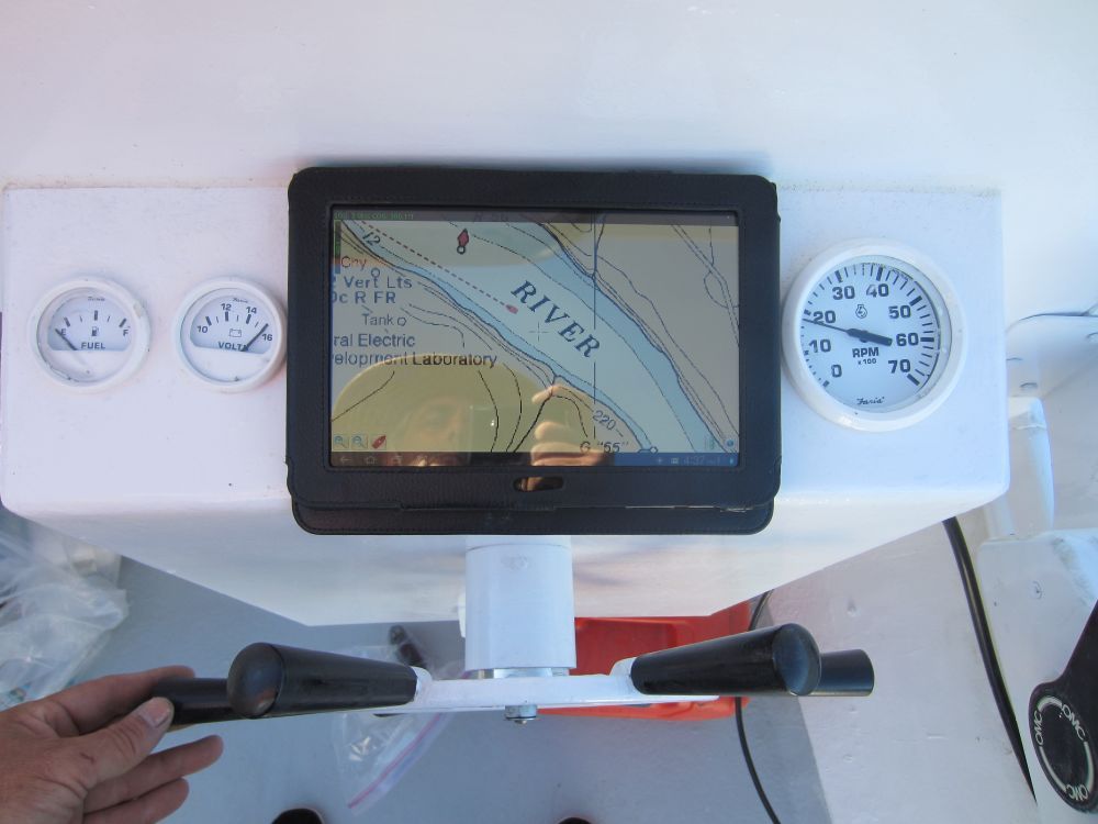
I have been using a Samsung 8" tablet as a gps/chartplotter for 3 years now. The biggest advantage for me is that most of the Marine navigation apps use NOAA raster charts which are electronic copies of the better detailed paper charts. The disadvantage to raster charts are they don't compress to work on small screens. Anything under a 5" screen is not IMO going to be easy to read while underway. Screen brightness (lack there of) has been an issue on sunny bright days when used out in the open cockpit. I just bought one of the new brighter screen Nexus 7 tablets recently to correct that issue. Waterproofing is accomplished with a vinyl sleeve for about $10 and charging power comes from the 12v accessory plug under the helm.
Along with the NOAA charts I also have OSM streetmaps, USACE Charts and US Topo maps stored on the device which helps with uncharted rivers and lakes.
For someone like me who never goes more than a few miles off shore this is a great setup for under $300
FWIW I have a $180.00 VHF with built in GPS that operates the DSC function.

IMG_0193.jpg
 

Attachments

  • IMG_0193.jpg
    IMG_0193.jpg
    74.2 KB · Views: 0
Top