How to plan a route? is there an app like trip advisor?

Joined
Jun 19, 2023
Messages
7
Looking to plan a trip from my slip in Martinez Ca up the Sacramento river to the capital.
I cant find anything online other then a map, but wondering if anybody has seen any?
Or any ideas you have to make this smooth as possible.
I'm guessing my Garmin 8612xsv has a way to set a route without autopilot?
Bucket list item.
thanks
 
Last edited:

Scott Danforth

Grumpy Vintage Moderator still playing with boats
Staff member
Joined
Jul 23, 2011
Messages
49,537
Get paper charts, map your route.
 

dingbat

Supreme Mariner
Joined
Nov 20, 2001
Messages
16,071
I'm guessing my Garmin 8612xsv has a way to set a route without autopilot?
It should have auto guidance if you have 3G charts installed.

If not the Vision+ chip has AG or you could download and use Garmin Active Captain AP
 

Chris1956

Supreme Mariner
Joined
Mar 25, 2004
Messages
27,840
Or you could look at the charts and plot your own route. Most GPS have a route feature, but you need to add the waypoints. Worse comes to worse, you will learn about the water conditions, buoys, channels etc. on your route. Not bad knowledge to have, when something unexpected happens.
 

brodmann

Chief Petty Officer
Joined
Jun 17, 2008
Messages
426
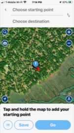
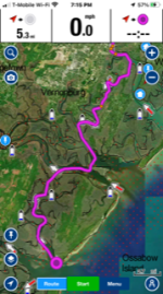
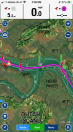
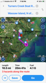
I have an app on my phone that's pretty awesome. It's "Navionics". Much like google maps and Wayz, you can actually type in a starting point (local marina) and a destination point and hit GO. It's pretty amazing. It gives depths, speed and if you enter some information about your boat it will calculate travel time and fuel consumption. It's a free download, 30 day free trial and I think I've had it about 5 years now and I think I pay $10/year. It's great, I can let my grandkids drive my boat. They just look at the screen keep the little boat in the middle of the channel. I love it. If you have a tablet, obviously you would have a much larger screen. I have a large cell phone and an automotive type holder and I'm good to go. I've included some screenshots.
 

Attachments

  • IMG_5447 (2).png
    IMG_5447 (2).png
    253.2 KB · Views: 3
  • IMG_5449 (2).png
    IMG_5449 (2).png
    275.7 KB · Views: 2
  • IMG_5450 (2).png
    IMG_5450 (2).png
    308.5 KB · Views: 3
  • IMG_5453 (2).png
    IMG_5453 (2).png
    245.3 KB · Views: 3
Joined
Jun 19, 2023
Messages
7
I have an app on my phone that's pretty awesome. It's "Navionics". Much like google maps and Wayz, you can actually type in a starting point (local marina) and a destination point and hit GO. It's pretty amazing. It gives depths, speed and if you enter some information about your boat it will calculate travel time and fuel consumption. It's a free download, 30 day free trial and I think I've had it about 5 years now and I think I pay $10/year. It's great, I can let my grandkids drive my boat. They just look at the screen keep the little boat in the middle of the channel. I love it. If you have a tablet, obviously you would have a much larger screen. I have a large cell phone and an automotive type holder and I'm good to go. I've included some screenshots.
Awesome I new someone made something.
Thanks for all the replies, Im reading watching up on all my Garmin model tutorials.
WOW there is alot of stuff to go through.

Haha I just looked on App store and there are many others, never thunk to look
 

brodmann

Chief Petty Officer
Joined
Jun 17, 2008
Messages
426
I tried a lot of the apps. Most have free trial periods, but the navionics is the only one I kept and paid for. I find it most like the apps on my phone for driving directions. Most of the places I launch from or go to pop up when I start typing, but if not, I can just find it on the map and go to Routes and Automatic, Just click on "choose starting point" twice and it will enter your current location, then click on "choose destination" and find your destination on the map and click on it. All 3 of my sons have the app and they all have boats. Some Saturdays, I'll ask them where they are, and they can send me their destination on the app, and I can go and spend some time on a beach somewhere with my kids and grandkids! It's perfect for me!
Hope you like it too!
 

Sprig

Chief Petty Officer
Joined
May 2, 2016
Messages
607
The Garmin 8612xsb is an awesome unit. As far as I know you can plot routes. You should be able to put in all the waypoints you want between Martinez and Sacramento. You can do so even with cheaper less sophisticated units. Read your instruction manual. It should contain all the information you need.
I’ve made the trip a few times from Sacramento past Martinez to San Francisco Bay and back. It’s an easy and pleasant trip. Hard to get lost or take a wrong turn especially with GPS. Easy trip.
You just go toward Sacramento, go under the Carquinez bridge (that is where the water starts turning from salt to fresh). Basically follow the shipping channel all the way to Rio Vista. At the mouth of the San Joaquin River the shipping channel splits , one goes up the San Joaquin to Stockton, the other continues straight up the Sacramento River to Rio Vista. Continue to Rio Vista, go under the Rio Vista bridge and in about a quarter mile right turn on the sac river. Stay towards the middle before and after making the turn. There is a nasty sandbar about 50 yards from shore just before you turn up the Sacramento. Just follow the Sacramento River all the way to sacramento.
Once you’ve made the trip you’ll see it’s easy peasy. Don’t know what size boat you have but be aware every afternoon the wind gets to howling and the large wide area before the Rio Vista bridge gets very rough. When the tide and current are going in the same direction and the wind in blowing in the opposite direction, 4’ and higher roller waves. Once you turn up the Sacramento River from Rio vista it will be relatively calm no matter what the wind.
I haven’t made the trip for a few years and I sold my boat last year but I know nothing has changed. I’ve been boating the Sacramento/San Joaquin delta for 50+ years. I know it pretty well. If you have questions let me know I’ll try to answer them for you.
 
Joined
Jun 19, 2023
Messages
7
The Garmin 8612xsb is an awesome unit. As far as I know you can plot routes. You should be able to put in all the waypoints you want between Martinez and Sacramento. You can do so even with cheaper less sophisticated units. Read your instruction manual. It should contain all the information you need.
I’ve made the trip a few times from Sacramento past Martinez to San Francisco Bay and back. It’s an easy and pleasant trip. Hard to get lost or take a wrong turn especially with GPS. Easy trip.
You just go toward Sacramento, go under the Carquinez bridge (that is where the water starts turning from salt to fresh). Basically follow the shipping channel all the way to Rio Vista. At the mouth of the San Joaquin River the shipping channel splits , one goes up the San Joaquin to Stockton, the other continues straight up the Sacramento River to Rio Vista. Continue to Rio Vista, go under the Rio Vista bridge and in about a quarter mile right turn on the sac river. Stay towards the middle before and after making the turn. There is a nasty sandbar about 50 yards from shore just before you turn up the Sacramento. Just follow the Sacramento River all the way to sacramento.
Once you’ve made the trip you’ll see it’s easy peasy. Don’t know what size boat you have but be aware every afternoon the wind gets to howling and the large wide area before the Rio Vista bridge gets very rough. When the tide and current are going in the same direction and the wind in blowing in the opposite direction, 4’ and higher roller waves. Once you turn up the Sacramento River from Rio vista it will be relatively calm no matter what the wind.
I haven’t made the trip for a few years and I sold my boat last year but I know nothing has changed. I’ve been boating the Sacramento/San Joaquin delta for 50+ years. I know it pretty well. If you have questions let me know I’ll try to answer them for you.
Great info thanks. Im in a slip in the martinez marina and its a 24' Osprey so really solid with the waves etc.
Ill be making the trip before end of summer. Happen to know how long it would take to go from carquinez B to Sacramento?
Maybe ill see you sometime.
 

Sprig

Chief Petty Officer
Joined
May 2, 2016
Messages
607
Great info thanks. Im in a slip in the martinez marina and its a 24' Osprey so really solid with the waves etc.
Ill be making the trip before end of summer. Happen to know how long it would take to go from carquinez B to Sacramento?
Maybe ill see you sometime.
You should be fine in your boat. Still it can get pretty rough around Rio vista in the afternoon so just exercise a little caution. I know the bay around Martinez can get rough too in the windy afternoons. Some days it’s calm around there but summertime is when the worst winds seem to happen.
As far as how long it takes, kind of tough to estimate. Most of my trips have been from around Brannon Is. area to sacramento area. You’ll run into several 5mph/no wake zones once you make the turn onto the Sacramento after the Rio Vista bridge which will slow you down. Watch out for them, the Sheriff will cite you if you don’t slow down.
Im guessing from the Brannon Is. area around Rio Vista maybe 2 1/2 hours or more, maybe a little less, hard to say. My last boat I’d run 30 mph to about 40 mph. From Martinez it’s going to be an all day round trip. I’d leave early in the morning cause the trip back is going to be slower if the afternoon winds come up and you are dealing with rough water.
Any other help I can offer let me know. A pleasant trip, you’ll enjoy it.
 
Top