Best Phone App for Charts

Jim x 3

Recruit
Joined
Oct 14, 2021
Messages
3
First time posting. I am looking to see what everyone is using for an app to view depth charts of lakes and rivers? Thanks for the help!
 

Scott Danforth

Grumpy Vintage Moderator still playing with boats
Staff member
Joined
Jul 23, 2011
Messages
49,537
Big ole garmin chart plotter. cant read my phone or any tablet in florida sun, so an app would be useless for me

for those that live in darker climates, navionics app
 

southkogs

Moderator
Staff member
Joined
Jul 7, 2010
Messages
14,919
The Hummingbird finder that I got a couple years ago has a decent set of maps for the lakes inland, and it can integrate with Navionics. I also have Navionics on my phone, and since I am rarely where I can't get reception I like the way Navionics works for me.
 

Alumarine

Captain
Joined
Feb 22, 2005
Messages
3,733
With the Navionics phone app you can download charts beforehand so it can be used without reception.
I don't have trouble using it on my phone or tablet.
 

dingbat

Supreme Mariner
Joined
Nov 20, 2001
Messages
16,071
With the Navionics phone app you can download charts beforehand so it can be used without reception.
I don't have trouble using it on my phone or tablet.
Most tablets and cells phones triangulate position off the cell towers.

How does the app updated your position w/o cell coverage?
 

icyb

Seaman Apprentice
Joined
Aug 28, 2018
Messages
39
Most tablets and cells phones triangulate position off the cell towers.

How does the app updated your position w/o cell coverage?
All android products have built-in GPS, you don't need data.
 
Joined
Mar 1, 2005
Messages
956
I-Phones have built-in GPS as well. I have never needed to use my navionics app away from cell signals, but I use the GAIA app while wondering in the woods far from cell towers. It uses GPS as well.

Mine is a little old (an iphone 7) so maybe things have improved, but I would never use my phone for precise navigation. The GPS just isn't as good. It can get you pointed in the right direction or near a fishing hole, but not much more than that.
 

Alumarine

Captain
Joined
Feb 22, 2005
Messages
3,733
Mine is a little old (an iphone 7) so maybe things have improved, but I would never use my phone for precise navigation. The GPS just isn't as good. It can get you pointed in the right direction or near a fishing hole, but not much more than that.
I find mine to be quite accurate and I use it as a backup in some very tricky to navigate areas.

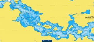
Screenshot 2021-10-28 151932.jpg
 

dingbat

Supreme Mariner
Joined
Nov 20, 2001
Messages
16,071
I find mine to be quite accurate and I use it as a backup in some very tricky to navigate areas.
Cell phones don't have a battery power to support "active" GPS like a chart plotter making for much slower and less precise position updates.

Would be interesting to know what your EPE is when using your phone for navigation?
 

Scott Danforth

Grumpy Vintage Moderator still playing with boats
Staff member
Joined
Jul 23, 2011
Messages
49,537
how are you all able to read a cell phone screen or a tablet screen in direct sunlight? not enough lumens on any consumer based cell phone or tablet.

any LED screen that is below 500 nits (Best one out there is 499 nits) will not be readable in direct sunlight. commercial screens 800 nits or higher may work. however my experience has been you need about 1200 nits to read with sunglasses on

then the device normally goes into over-heat shut-down

there are LCD tablets that work until the screen temp is about 140F. then the LCD stops working.
 

southkogs

Moderator
Staff member
Joined
Jul 7, 2010
Messages
14,919
I played with Navionics to see how accurate it was several years ago. I was on iPhone 4 or 5 at the time. You can see the results HERE. Honestly, I was pretty impressed.

Here in TN, I can keep the screen shaded and typically only need the chart view for a short time. When I was on the ICW using the phone, Scott's right - it could be tough to see. I had a bimini over top of me and could see well enough most of the time, but at certain angles it was tricky and I'd have to get some shade over the screen. I think I had to even slow the boat way down once or twice and look closely at the screen.

As I recall, it was quite the battery eater too.
 

Jim x 3

Recruit
Joined
Oct 14, 2021
Messages
3
Thank you for all of the good feedback. I will have the Garmin on the boat I mainly wanted to use it to look up locations to go on the rivers and lakes before I go try to get into certain locations.
 

Scott Danforth

Grumpy Vintage Moderator still playing with boats
Staff member
Joined
Jul 23, 2011
Messages
49,537
Thank you for all of the good feedback. I will have the Garmin on the boat I mainly wanted to use it to look up locations to go on the rivers and lakes before I go try to get into certain locations.
you can view the navionics maps for free on their website to do that.

same with the USGS maps
 

ejnichol

Petty Officer 2nd Class
Joined
May 28, 2002
Messages
143
The last time boating on the coast at 3-4 yrs back to Manteo with my lake boat required something better than just staying in channel and 'does that look deep enough'.

Found and app called MX Mariner and it work really well for free on an android phone. I imagine it is availabe for iphone. If you using for lakes I don't know that it has charts for that though. It does have good charts that you download for different sections of US coast.

My new to me April 2021 lake boat I went deep into $$ and invested in an engine gate way and Axiom 7 to get accurate speed and engine rpm etc.. at the helm.

THis investment started out after trying to get right prop on boat and struggled with inaccurate steam guages. Tried my old car Garmin but like previous had said it was really dim in full sunlight but was able to get accurate speed off of it though.
 

ejnichol

Petty Officer 2nd Class
Joined
May 28, 2002
Messages
143
With the Navionics phone app you can download charts beforehand so it can be used without reception.
I don't have trouble using it on my phone or tablet.
Is the Navionics phone app free? Does it include Lake charts for phones?
 

southkogs

Moderator
Staff member
Joined
Jul 7, 2010
Messages
14,919
You can use the app for free, but it doesn't have all of the chart data. You have to subscribe to get all of the data. I think the charts that I purchased in the past ran me about $30.

The online planning viewer is very good too, like Scott said.
 
Top