Why do ENC charts not show lighthouse characteristics?

rcspencer1

Cadet
Joined
Sep 21, 2001
Messages
17
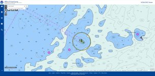
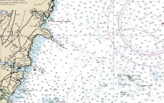
For some reason, the "new" ENC charts don't show the characteristics of lighthouses, so I'm wondering why? I've looked at many to confirm this, but for example the attached clip of Boon Island light off of York ME the raster chart shows "Fl 5s 137ft 14M" but nothing on the ENC chart. Same with the iconic Nubble Light which you can see in the attached raster chart -what gives? ENC charts: https://nauticalcharts.noaa.gov/enconline/enconline.html
 

Attachments

  • ENC snip Boon Island.JPG
    ENC snip Boon Island.JPG
    280.8 KB · Views: 1
  • Raster chart Boon Island and Cape Neddick Lighthouses.JPG
    Raster chart Boon Island and Cape Neddick Lighthouses.JPG
    289.7 KB · Views: 1

dingbat

Supreme Mariner
Joined
Nov 20, 2001
Messages
16,150
For some reason, the "new" ENC charts don't show the characteristics of lighthouses, so I'm wondering why? I've looked at many to confirm this, but for example the attached clip of Boon Island light off of York ME the raster chart shows "Fl 5s 137ft 14M" but nothing on the ENC chart. Same with the iconic Nubble Light which you can see in the attached raster chart -what gives? ENC charts: https://nauticalcharts.noaa.gov/enconline/enconline.html
Sounds like a works in process....
The charts are being converted from Raster to Vector maps. With that being the case, any "graphics" would need to be verified then replaced with "clickable" details.

 
Last edited:
Top