Seeking Advice: Real-Time Bathymetry Solutions for a 25-Foot Boat

Ben_newbie

Recruit
Joined
Nov 28, 2023
Messages
2
Hello,

I'm exploring options for a real-time bathymetry system for my 25-foot boat. My primary aim is to build my own accurate, real-time personal seafloor maps, even while cruising. I've noticed that professional fishermen use such systems effectively for a deeper understanding of the topography of fishing spots, which is exactly what I'm interested in.

I'm particularly keen to hear from those with firsthand experience in using real-time bathymetry systems. Could you share your insights on the following:

  1. Models and Brands: Which models or brands have proven to be superior in terms of accuracy and ease of use?
  2. Key Features: Are there any essential features or capabilities that I should look for?
  3. Value for Money: While my budget is flexible, I'm interested in a system that offers a good balance of cost and quality.
Your advice and suggestions would be greatly appreciated. Feel free to send me a private message if you prefer.
 

alldodge

Moderator
Staff member
Joined
Mar 8, 2009
Messages
42,047
Welcome
Have heard of the system but never found someone that used it outside of marine biologists

Hope someone here has used them and can advise
 

dingbat

Supreme Mariner
Joined
Nov 20, 2001
Messages
16,066
What exactly are you trying to do?
How deep and what is your budget?

"Real-time bathymetry systems" and "value" don't belong in the same paragraph.

Have a friend who just retired as an acoustical expert for Naval Research. The "fish" they tow for mapping cost more than the average home

The practical limit for "recreational" sonar is roughly 1,200 feet. Cost you between $5-10k for a decent unit.

As an offshore fisherman, I'm not all that interested in the bottom as most species are found in the top 100' of the water column. Side scan, spot light sonar and SST data is the most popular means to target species in open water

If fishing inshore, nothing bets local knowledge as things can change daily. One storm will Invalidate the chart you made yesterday
 

Scott Danforth

Grumpy Vintage Moderator still playing with boats
Staff member
Joined
Jul 23, 2011
Messages
49,531
Down here in the ICW, the charts change with the tides as the channels move.

For most charter captains, local knowledge and GPS coordinates where the man-made reefs are usually all that's needed in deep water
 

Ben_newbie

Recruit
Joined
Nov 28, 2023
Messages
2
Thanks everyone for your input. To clarify, I'm focused on detailed real-time bathymetry for fishing spots in 20-200m water depths. While I understand concerns about cost and practicality, I'm interested in a system that offers deep insights into seafloor topography, not just navigation.

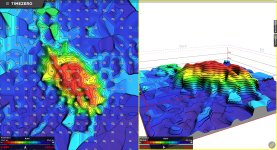
I came across TZ software, which provides the kind of detailed seafloor imaging I'm looking for( attached image).
This software runs on Windows and requires a PC or a laptop.
I'm curious to know your thoughts on this kind of system ( both the software and the hardware )?

I understand that such technology might be an investment, but I believe the value it offers in terms of precise and informed fishing could be significant. Any further thoughts or suggestions on this would be greatly appreciated.

Looking forward to your responses!
 

Attachments

  • bathymetry.jpg
    bathymetry.jpg
    1.9 MB · Views: 4

dingbat

Supreme Mariner
Joined
Nov 20, 2001
Messages
16,066
Thanks everyone for your input. To clarify, I'm focused on detailed real-time bathymetry for fishing spots in 20-200m water depths. While I understand concerns about cost and practicality, I'm interested in a system that offers deep insights into seafloor topography, not just navigation.

I came across TZ software, which provides the kind of detailed seafloor imaging I'm looking for( attached image).
This software runs on Windows and requires a PC or a laptop.
I'm curious to know your thoughts on this kind of system ( both the software and the hardware )?

I understand that such technology might be an investment, but I believe the value it offers in terms of precise and informed fishing could be significant. Any further thoughts or suggestions on this would be greatly appreciated.

Looking forward to your responses!
I see some value in the software for a trawler, but not so much as a competitive hook and line angler.

What advantage does this software provide over that of a good set of charts, a quality fish finder with side scan the most recent SST readout buy me?

No word salad....be specific with details. Maybe I'll learn something

FWIW: I'm a big Furuno fan. Ran one for years. Had to go elsewhere to get CHIRP side scan
 

garbageguy

Lieutenant Commander
Joined
May 8, 2012
Messages
1,574
Aside from the objective or application...

We (at work) had bathymetric-survey done for shallow sedimentation basins at our site, and had the resulting surface tied-into a UAV survey surface of the surrounding site that is above liquid-level surface.
1701538261469.png
 

rolmops

Vice Admiral
Joined
Feb 24, 2002
Messages
5,419
I did something a bit comparable on Lake Ontario. With the help of a Lowrance depth map,and a Furuno 588 with an airmar 262 transducer. I pointed a camera at both the screens and taped the film. The end result was a narrow line with very precise depth reading and irregularities. I pinpointed the interesting obstacles and the current speed at bottom with a fish hawk X4D which I wrote up in a log with exact location mentioned. That way I created my own "hot spots" or, so I thought. One good storm threw everything in disarray and made my information obsolete. This was on a soft bottom that was between 90 and 150 feet down. My conclusion was that depth, temperature and current speed at the desired depth are the most important. At least in Lake Ontario, location was far less important.
I think it is more important to understand fish location in its own environment. While observing fish from our environment it seems that the fish move in this or that direction, while the fish is often just about standing still in its own environment, but is carried along in a huge patch of water which moves as a whole by itself ,often pushed around by wind. like passengers in a car that passes you by because it goes just a bit faster. the passengers sit still ,but the car moves and moves the passengers away from you.. Still , it is an interesting experiment.
 
Top