OK, Going to venture where no man has gone before...in the boat!

scooper77515

Senior Chief Petty Officer
Joined
Sep 3, 2010
Messages
753
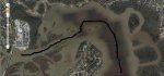
I am trying to figure out how to get from our lake to a point up into one of the rivers that feed into it. The one river has a couple of really nice restaurants right on the water. And after 3 years, we have yet to figure out how to navigate up into the river to the restaurants.

Well...tomorrow, I plan of figuring out how to get up there. I have a gps map on my cell phone, and a hand-held gps used for keeping speed on the boat when wake boarding.

So...any suggestions on how to figure out how to get upstream?

Lake Houston, trying to get up the West Fork San Jacinto river, for what it's worth...
 

Blake0912

Petty Officer 1st Class
Joined
Oct 31, 2010
Messages
313
Re: OK, Going to venture where no man has gone before...in the boat!

Ive done it before but it was over a year ago not sure if things have changed any. Anyways ill try to explain it best i can. If you are going North along the lake running next to atascocita shores you will see a island, go around the island (wide left) if you go in between the island and the land you will hit a sandbar. Stay wide towards the right shore bank while going around the island then you should be able to line up with the river leading right up to the Kingwood bridge. Just go slow and watch your depth finder until you are in deeper water. And most of the time theres people running around over there maybe you will get lucky and can follow them. Thats the best i can explain it while typing. Good luck hope this helped you a little bit.
 

a1akeywest

Banned
Joined
Oct 26, 2010
Messages
49
Re: OK, Going to venture where no man has gone before...in the boat!

best way to do it is to get a map of the waters you are travelling,, they will be very helpfull, and show you depths and obsticals to avoid..
 

partskenn

Petty Officer 1st Class
Joined
Jan 23, 2011
Messages
249
Re: OK, Going to venture where no man has gone before...in the boat!

Yea, buy a chart. Amazing how much info on them.
 

jigngrub

Fleet Admiral
Joined
Mar 19, 2011
Messages
8,155
Re: OK, Going to venture where no man has gone before...in the boat!

Look back every once in a while when you're heading upstream... stuff doesn't look the same on the way back.:rolleyes:
 

scooper77515

Senior Chief Petty Officer
Joined
Sep 3, 2010
Messages
753
Re: OK, Going to venture where no man has gone before...in the boat!

if you go in between the island and the land you will hit a sandbar.

Yeah, did that the first time.

I have the map, but it shows that area as all being under the 5' contour line. That could be 4'-9" or 6", or less. So really there is no useable information for that area. My Navionics maps on my cell phone are the same way. It goes into a little more detail and lists "shallow" in that area...

One time I asked some kids in a john boat if they knew the way and they said "sure, going that way now". so we followed them. Until their engine popped up out of the water as they hit a sandbar.

I know it can be done, because I see people coming and going from there all the time. Often in much bigger boats than mine. So hopefully I can catch up with one today and learn the way.

Thanks Blake for your advice. That is the best I have gotten so far. Seems counter-intuitive to go that way, but I guess that is the way the channel flows in that area, and why I have never tried that direction.
 

fat fanny

Lieutenant Commander
Joined
Feb 9, 2006
Messages
1,935
Re: OK, Going to venture where no man has gone before...in the boat!

Can you set your way point on your gps from land @ the resturant and then just use that on water from the general area of the channel? Just a suggestion good luck!
 

tx1961whaler

Vice Admiral
Joined
May 31, 2008
Messages
5,197
Re: OK, Going to venture where no man has gone before...in the boat!

Here is the channel. It's been a few years, but..
 

Attachments

  • LakeHouston.JPG
    LakeHouston.JPG
    70.8 KB · Views: 0

Boobie Trap

Petty Officer 2nd Class
Joined
Feb 21, 2011
Messages
122
Re: OK, Going to venture where no man has gone before...in the boat!

You can also try using Google Earth. They have refined it greatly and you can print the route. It does not tell you the depth of the water though.

I use it all the time looking for coves etc. Works great!!

"Boobie Trap"
 

scooper77515

Senior Chief Petty Officer
Joined
Sep 3, 2010
Messages
753
Re: OK, Going to venture where no man has gone before...in the boat!

Thanks TXwhaler! That is EXACTLY what I needed.

Printed it out and will try it next time we go out. Chickened out today. Got REALLY windy and I didn't want to keep going north on the lake with a south wind. I got about halfway up and was getting hit by waist-high waves!
 

Blake0912

Petty Officer 1st Class
Joined
Oct 31, 2010
Messages
313
Re: OK, Going to venture where no man has gone before...in the boat!

txwhaler thats the route i was trying to explain...guess i should of thought of making a picture lol. The last time i did it i was in my 13ft whaler but i have done it in my CC bay boat one time just messing around. You will make it. Just mark it on your navionics map i think you can save routes on there.
 

scooper77515

Senior Chief Petty Officer
Joined
Sep 3, 2010
Messages
753
Re: OK, Going to venture where no man has gone before...in the boat!

Yes, I just figured out yesterday that the Navionics has options for marking trails and way points.

Thanks a bunch, guys! It's going to be cool pulling up to those restaurants in a boat!
 

scooper77515

Senior Chief Petty Officer
Joined
Sep 3, 2010
Messages
753
Re: OK, Going to venture where no man has gone before...in the boat!

Weather is awesome today! If wife can get home at decent time, we will try to get to Kingwood for dinner.

i will let you guys know how it goes!
 

scooper77515

Senior Chief Petty Officer
Joined
Sep 3, 2010
Messages
753
Re: OK, Going to venture where no man has gone before...in the boat!

We failed.

Got to the point where we should have been getting ready to turn at the tip of that island, and depthfinder went dead. Just read 6.0 blinking, and didn't change readings. So I kicked on the fishfinder and was in 4' of water, got to 2' and stopped. We then went side to side in 2' looking for a deeper spot to go through. 2' is actually closer to 3 or 3.5' since the transponder is about a foot under water, but still too shallow for my comfort. Saw a boat hauling balz toward us so we waited to see where he went through. Ended up being a small jon boat, so it really didn't matter.

Water was down on the lake everywhere. We would not have been able to dock at the restaurants because the dock would have been hitting our wake tower.

Down about 2' even at our ramp. So maybe we just need to wait for a rain and try again.

Drove boat back home and drove the car to the restaurant.
 
Top