Laceyville on a fishfinder?

Kiggsia

Petty Officer 3rd Class
Joined
Sep 18, 2008
Messages
98
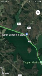
Has anyone ever been on a boat on Lake Tappan in Ohio and seen the sunken village of Laceyville on their fishfinder? I am wanting to find it with my Raymarine Element but would need to know just where it is, if there are still buildings intact enough to be visible since it's being underwater since 1933.
 

Attachments

  • Screenshot_20220814-154816_Maps.jpg
    Screenshot_20220814-154816_Maps.jpg
    569.1 KB · Views: 5

rollingSC

Recruit
Joined
Jul 22, 2022
Messages
3
There are suspicions that there is nothing left of the city, otherwise I will be very surprised that there are no notes about it on the Internet o_O
 

Kiggsia

Petty Officer 3rd Class
Joined
Sep 18, 2008
Messages
98
Sadly, I agree. Thanks for reply. However, recently I have seen things online in forum type discussions about a person seeing the top of a Church steeple during Tappan Lake's annual low water cycle, and I saw a map that pointed out the location of a sunken bridge. And one commenter said there were more sturdy things down there like old cars, a tractor, mailboxes. But except for the sunken bridge comment, no locations given. I saw a satellite image this Monday of a big, very visible sunken roadbed next to the dam. Perpendicular to that were faint images of what looked to me like a small grid of village streets. That may be all that can be seen now of Laceyville. One facebook person I had been discussing Laceyville with and a boater on the lake when I was down there said thats the area whre Laceyville was. And there are online articles that seem to imply that there are remains of Laceyville still there & another village under the lake also called Tappan. But here again, no mention of where. I will attach the Google satellite photo of what had looked like village streets but it is very hard to see, very faint. It's best to look at the picture in a dark room. A lady that works at the park there said the water is murky at the bottom but that seems to be the case in the center of the long lake. Doesnt look that murky by the dam. And plus I'm using sonar to look for objects, not an underwater camera.Screenshot_20220822-140132_Maps.jpg
 
Last edited:

cptbill

Senior Chief Petty Officer
Joined
Oct 6, 2012
Messages
742
This is a very curious post, so after a little research it's said that there a 3 towns under water in that lake. Don't know if that's true but it's kind of neat
 

FLATHEAD

Commander
Joined
Dec 29, 2002
Messages
2,971
Hope you find at least something. The rumors of a church steeple being seen at low water times is prevalent on many lakes that flooded where towns were. No truth to most of them. I can see on down imaging where a car is on one lake I fish. And can see a roadbed and an old stone bridge on another. My wife’s grandfather lived just above a town that they flooded when a reservoir was built. He had a photo journal of progress. All buildings were demolished. One roadbed was left intact.
 

Grub54891

Vice Admiral
Joined
Jun 17, 2012
Messages
5,915
I'd imagine they would have taken the buildings down so debris wont float away causing damage to boaters or plugging up the dam.
 

Kiggsia

Petty Officer 3rd Class
Joined
Sep 18, 2008
Messages
98
I'd imagine they would have taken the buildings down so debris wont float away causing damage to boaters or plugging up the dam.
That makes sense, I have heard of a clearing crew before the flooding. It's just that Google had news posts with titles like how there are underwater villages in Tappan Lake that not many people know exist. So I went there with my Raymarine Element fishfinder to see what might be left. One commenter online talked about how there are sunken cars down there & a tractor. But I know we can't believe everything we read online. Another commenter said that when the lake is drained in the fall to permit more floodwater in the lake, he saw a Chuech steeple! More fake news type stuff no doubt. Probably much more creditability to those who claim to have seen the Loch Ness monster over in Loch Ness. So I need to think of how a village, named Laceyville, WAS down there not IS down there.
 

Kiggsia

Petty Officer 3rd Class
Joined
Sep 18, 2008
Messages
98
Hope you find at least something. The rumors of a church steeple being seen at low water times is prevalent on many lakes that flooded where towns were. No truth to most of them. I can see on down imaging where a car is on one lake I fish. And can see a roadbed and an old stone bridge on another. My wife’s grandfather lived just above a town that they flooded when a reservoir was built. He had a photo journal of progress. All buildings were demolished. One roadbed was left intact.
What and where is that lake with the car? My new hobby is the challenge of looking for such things with my Raymarine Element fishfinder. But once a sunken car came to me, I didn't have to search for it. A pond in my neighborhood was drained for cleanout and a stolen ditched car emerged into view!
 

aspeck

Moderator
Staff member
Joined
May 29, 2003
Messages
18,603
In Lake Raystown you can find 2 bridges under water, the old dam, and a stone house. The stone house was left intact (except the roof) because stone doesn't float, I guess ... but you can see it on your graph and divers dive it often. Every other building was demolished before the lake was filled. All trees were removed that the tops would be within 25 feet of the normal water level (lake is 195 feet at the deepest) ... there are certainly forests under the water that will eat your downrigger balls and lures.
 

flashback

Captain
Joined
Jun 28, 2002
Messages
3,700
not to far from me..
 

Kiggsia

Petty Officer 3rd Class
Joined
Sep 18, 2008
Messages
98
In Lake Raystown you can find 2 bridges under water, the old dam, and a stone house. The stone house was left intact (except the roof) because stone doesn't float, I guess ... but you can see it on your graph and divers dive it often. Every other building was demolished before the lake was filled. All trees were removed that the tops would be within 25 feet of the normal water level (lake is 195 feet at the deepest) ... there are certainly forests under the water that will eat your downrigger balls and lures.
Thanks for reply, i am intriqued, but where is lake Raystown? That sounds more interesting than my next trip plan to use gps coordinates to find what a rocky reef in Lake Erie, Turtle Reef, looks like on sonar. Rocks turn out real good, a good quality sonar image looks at the level of a poor quality sepia photo. Hopefully my Element will allow me to input GPS coordinates without subscribing to the Navionics navigation program
 

aspeck

Moderator
Staff member
Joined
May 29, 2003
Messages
18,603
Thanks for reply, i am intriqued, but where is lake Raystown? That sounds more interesting than my next trip plan to use gps coordinates to find what a rocky reef in Lake Erie, Turtle Reef, looks like on sonar. Rocks turn out real good, a good quality sonar image looks at the level of a poor quality sepia photo. Hopefully my Element will allow me to input GPS coordinates without subscribing to the Navionics navigation program
Central PA ... The dam is just a few miles southeast of Huntingdon and the headwaters are southeast, 30 miles away, in Saxton, PA
 

FLATHEAD

Commander
Joined
Dec 29, 2002
Messages
2,971
What and where is that lake with the car? My new hobby is the challenge of looking for such things with my Raymarine Element fishfinder. But once a sunken car came to me, I didn't have to search for it. A pond in my neighborhood was drained for cleanout and a stolen ditched car emerged into view!
It’s in Montgomery county Pa. Green lane reservoir. Be prepared if you head this way. Lake has a ten day quarantine for boats to keep zebra mussels out of the lake. It electric motors only and you need some serious juice to spend a day there. I keep a boat there.

The bridge is in Lake Nockamixon in Bucks county Pa. 1500 acres open to any boats but HP is restricted to 20.
 

southkogs

Moderator
Staff member
Joined
Jul 7, 2010
Messages
14,796
There were a lot of rumors about homes and buildings under the impounds here in Tennessee when they dammed up the rivers. From what I've gathered, the couple of towns that were actually flooded had most of their buildings torn down. The foundation of the old school building is under Dale Hollow, but not the complete building. I've not heard of any standing buildings that one can find underwater.
 
Top