Garmin navigation map help

gam101

Petty Officer 3rd Class
Joined
Jun 3, 2012
Messages
79
Hello folks! I've just installed a Garmin 54CV on our boat for salt water fishing. And I'm trying to use the navigation maps to determine fishing spots.

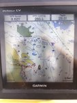
So, could someone please help me understand the attached navigation map?

For example; I have no clue what the "light blue patches" are, or what the numbers mean (I'm thinking depth maybe?), or what the blue lines imply.

Any other pointers in using this Garmin for fishing would be much appreciated too.
 

Attachments

  • photo306977.jpg
    photo306977.jpg
    124.2 KB · Views: 4

TBarCYa

Senior Chief Petty Officer
Joined
Apr 13, 2005
Messages
781
The numbers are depth, normally in feet. The blue lines designate depth changes. The light blue patches are probably shoals or shallow areas.
 

gam101

Petty Officer 3rd Class
Joined
Jun 3, 2012
Messages
79
The numbers are depth, normally in feet. The blue lines designate depth changes. The light blue patches are probably shoals or shallow areas.

Got it! And any difference between the blue & the light-gray lines? Appreciate the help, again.
 

StingrayMike

Petty Officer 1st Class
Joined
Aug 17, 2014
Messages
355
Garmin has a lot of "How to Videos" posted out there. just do a google search and they do a good job of explaining things.
 

Kola16

Petty Officer 2nd Class
Joined
Jun 23, 2019
Messages
160
The dark blue areas are "pretty" shallow, and the light blue are "extremely" shallow. I would stay away from both! Also if you would like more chart definition (contour lines) when you are fishing, then use your "Fishing Chart" instead of your "Navigation Chart." Your fishing chart gives contour lines every 6 ft so you can really pinpoint all the humps and drop-offs.
 

Kola16

Petty Officer 2nd Class
Joined
Jun 23, 2019
Messages
160
Whoops, did not realize this thread was so old. Darn noobs anyway:facepalm:
 
Top