Any Lowrance HDS-7 Users?

JoLin

Vice Admiral
Joined
Aug 18, 2007
Messages
5,146
Gonna need a new GPS come Spring. I could take the easy way out and just buy a Garmin 546s, but the Lowrance is also hi-res and has a bigger screen (6.4" vs. 5") for about the same amount of money.

Anybody on here using one? Does it work well? Pros and cons?

Thanks!
 

lime4x4

Lieutenant Junior Grade
Joined
Apr 25, 2007
Messages
1,040
Re: Any Lowrance HDS-7 Users?

I have the hds-10 unit with insight. I couldn't be more pleased with it. Very good map detail
 

dingbat

Supreme Mariner
Joined
Nov 20, 2001
Messages
16,915
Re: Any Lowrance HDS-7 Users?

Your comparing apples to oranges.

The Garmin comes with maps. The Lowrance does not.

The one thing you want to look at is how the maps are presented.

The Garmin displays look exactly like the chart books you're used to seeing.
STA60013.JPG


Lowrance maps look like cartoons, for lack of a a better word.
navcb.png


Suggest you take a look for yourself
 

lime4x4

Lieutenant Junior Grade
Joined
Apr 25, 2007
Messages
1,040
Re: Any Lowrance HDS-7 Users?

Sorry i have to disagree with u on the maps. My maps that came with my hds-10 are more chart looking. I know there are 2 versions of insight that comes with the hds unit's. plus mine has either 2d or 3d mapping
 

JoLin

Vice Admiral
Joined
Aug 18, 2007
Messages
5,146
Re: Any Lowrance HDS-7 Users?

Maybe I should have specified that I was referring to the HDS-7 units that come with Lowrance's 'Nautic Insight' as part of the package. From what I've seen it looks similar to Garmin's built-in charts.

There are further upgrades available for both (g2 Vision and Navionics), but I was referring to the Garmin basic unit vs. a similarly equipped Lowrance- 'apples-to-apples'.
 

Boatist

Rear Admiral
Joined
Apr 22, 2002
Messages
4,552
Re: Any Lowrance HDS-7 Users?

You can get the lowrance units without Charts or with Ocean Charts or Inland Charts.
You can also run Navionics Charts.
My only complant with the lowrance Charts is it either Ocean Charts or Inland charts.
So if I buy a unit with Ocean Charts for my boating in California I get the charts the West Coast, the Gulf Coast and the East Coast.
I do not know a single person who would use the charts for all the entire USA Coast.

Instead I would rather have a Chart that included all the charts for California.
So if I launch My boat in San Francisco Bay and head out into the Pacific Ocean I would have detailed charts for both Inland and Ocean waters.
With Lowrance you either get details inland or the Ocean not both.
Yes you can buy the units with Ocean charts and add an SD card with the Inland Charts then switch to the right one when you cross the line.

I have not checked in a few years but Garmin was the same way.
 

dingbat

Supreme Mariner
Joined
Nov 20, 2001
Messages
16,915
Re: Any Lowrance HDS-7 Users?

Sorry i have to disagree with u on the maps. My maps that came with my hds-10 are more chart looking. I know there are 2 versions of insight that comes with the hds unit's. plus mine has either 2d or 3d mapping

Same area, same map scale. Garmin above, Lowrance below

Note the red circle around G87 bouy on the Garmin chart. It's mssing on the Lowrance chart. G87 was installed in 1997 so that tells me that this Lowrance chart has not been updated since 1997. Wonder what else is missing from the chart?

maps1.jpg


navcb.png
 

NYBo

Admiral
Joined
Oct 23, 2008
Messages
7,107
Re: Any Lowrance HDS-7 Users?

I find the Lowrance chart more readable due to the additional shading of the water at different depths (but the scales aren't exactly the same), but the failure to update the chart makes it a no-brainer. Are you sure that's the latest chart available for the Lowrance?
 

lime4x4

Lieutenant Junior Grade
Joined
Apr 25, 2007
Messages
1,040
Re: Any Lowrance HDS-7 Users?

I had to dig out my hds-10. The charts that are loaded onto mine show that bouy. I just found it hard to beleive That the mapping software is that old. I just bought be hds unit 4 months ago

shot%204.png
 

JoLin

Vice Admiral
Joined
Aug 18, 2007
Messages
5,146
Re: Any Lowrance HDS-7 Users?

Lime, I like what I'm seeing. My needs are pretty simple (waypoints, routes and backtracking if need be). Readability, as in screen size and resolution, is an important decision factor for these old eyes :)

I'm leaning toward the Lowrance at this point.

Thanks to everybody for the input.
 

dingbat

Supreme Mariner
Joined
Nov 20, 2001
Messages
16,915
Re: Any Lowrance HDS-7 Users?

I had to dig out my hds-10. The charts that are loaded onto mine show that bouy. I just found it hard to beleive That the mapping software is that old. I just bought be hds unit 4 months ago

Look at the bottom left hand corner of each chart. It will give the edition date of the chart. A large precentage of the "offical" charts are outdated by as much as twenty-five years. This is why you are notifed when you boot your machine that it is not to be used as the sole means of navigation.

The bouy (G87) isn't identified on your chart and either is the wreck that it's marking. Do you have your "detail" turned down low?

Here are the offical NOAA charts. Anyone can check the content and dates of their maps here. http://www.charts.noaa.gov/OnLineViewer/AtlanticCoastViewerTable.shtml
 

lime4x4

Lieutenant Junior Grade
Joined
Apr 25, 2007
Messages
1,040
Re: Any Lowrance HDS-7 Users?

I will look this afternoon. Honestly this unit has so many settings and views i'm still trying to get a feel for the unit. I will play more with it later and post the results
 

lime4x4

Lieutenant Junior Grade
Joined
Apr 25, 2007
Messages
1,040
Re: Any Lowrance HDS-7 Users?

after playing around a little with the settings. Still don't know what i'm doing..lol but bouy wr87 is marked.

shot%205.png


shot%206.png


shot%207.png
 

lime4x4

Lieutenant Junior Grade
Joined
Apr 25, 2007
Messages
1,040
Re: Any Lowrance HDS-7 Users?

also my built in chart is dated 2009
 

jhebert

Ensign
Joined
Jul 24, 2005
Messages
903
Re: Any Lowrance HDS-7 Users?

I have a Lowrance HDS-8 with the Insight US chart option, version 3.6, copyright 2009.

My cartography clearly shows the WR87 buoy which has become the point of argument in this thread.

I think it is something of a specious argument to say one ought to buy or not buy a particular combination GPS receiver, display, SONAR, and included digital cartography package on the basis of whether or not there is one buoy somewhere in North America which is shown or not shown. It is exceedingly likely that one may never encounter that particular buoy during their boating, so whether or not the digital cartography package contains that aid is not particularly important to most purchasers. It is also likely that even the package of digital cartography which shows a particular buoy may also omit others or contain other errors. The official NOAA charts often contain errors which are far more significant than the omission of a particular buoy.
 

JoLin

Vice Admiral
Joined
Aug 18, 2007
Messages
5,146
Re: Any Lowrance HDS-7 Users?

jhebert- fully agree with you. I purposely avoided the 'which is better?' type of thread, because it only causes trouble. I know other manufacturers make good GPS's, but that wasn't my question.

I've done the basic research and felt that the HDS-7 was a good choice at my price point.

From what I've gathered, those who are using the HDS-series GPS's, seem to like them. No one has reported any issues, so the HDS-7 will remain on my short list.

(heck, if I had the cash I'd buy a Garmin 740)

Thanks.
 

dingbat

Supreme Mariner
Joined
Nov 20, 2001
Messages
16,915
Re: Any Lowrance HDS-7 Users?

I have a Lowrance HDS-8 with the Insight US chart option, version 3.6, copyright 2009.

My cartography clearly shows the WR87 buoy which has become the point of argument in this thread.

I think it is something of a specious argument to say one ought to buy or not buy a particular combination GPS receiver, display, SONAR, and included digital cartography package on the basis of whether or not there is one buoy somewhere in North America which is shown or not shown. It is exceedingly likely that one may never encounter that particular buoy during their boating, so whether or not the digital cartography package contains that aid is not particularly important to most purchasers. It is also likely that even the package of digital cartography which shows a particular buoy may also omit others or contain other errors. The official NOAA charts often contain errors which are far more significant than the omission of a particular buoy.

Copyright dates on 3rd party maps mean absolutely nothing. You can compile 10 year old data and get 2009 copyright date. The map of that area is comprised of the following NOAA charts.
Chart 12270, dated 8/1/2006
Chart 12282, dated 10/1/2005
Chart 12266, dated 12/1 2009

One buoy is not the point. A chart plotter as a navigation tool. The rate of which the charts are updated is a factor in the performance of the unit. If company X updates their charts every 6 months and company Y updates theirs every 3-5 years, which device is a better navigational tool at any given time? If you want to marginalize the accuracy of the charts by promoting the sonar and displays so be it. It?s your choice. Perhaps your sonar will warn you of that "unmarked" superstructure that you?re about to run before it tears the bottom off your boat.

As far as the buoy is concerned, this North American buoy "that is exceedingly likely that one may never encounter" is on the approach to the Port of Baltimore and within sight of the US Naval Academy in Annapolis. Over 30 million tons of cargo and thousands upon thousands of commercial, recreational and military vessels pass by this buoy every year which marks a wreck in the shipping channel.
 

lime4x4

Lieutenant Junior Grade
Joined
Apr 25, 2007
Messages
1,040
Re: Any Lowrance HDS-7 Users?

I went with lowrance cause of all the stuff that is offered. I have sirrius weather and music. my lowrance vhf connects on the nmea 2000 network and i recently just got the sonichub setup
 

jhebert

Ensign
Joined
Jul 24, 2005
Messages
903
Re: Any Lowrance HDS-7 Users?

I mentioned the version number and copyright date of my cartography only to identify what version I had. There is no implication in anything I said that the cartography was guaranteed to contain all navigation aids for the entire United States as of any particular date.

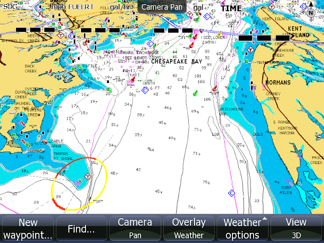
Again, it is pointless to use a single aid to navigation as the benchmark for evaluation of any collection of charts covering the entire United States. I bought a NOAA chart which had a very serious error in an aid to navigation--does that mean I ought to never trust NOAA charts again?

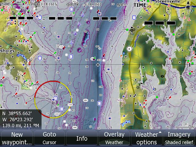
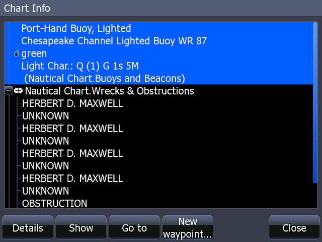
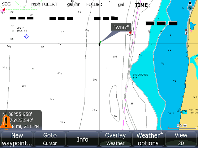
Here is the coup d'grace that just buries the argument that was made about WR87--Everyone has that aid on their LOWRANCE chart plotter! It is a non-issue. Even thought the "test" proposed was completely arbitrary, LOWRANCE cartography has passed the test.

By the way, the reasons I bought the HDS-8 were:

--NMEA-2000 compatible
--screen capture to memory card
--plays nicely with AIS receivers
--modern digital SONAR
--moderate price
--good cartography available

The display is very bright, and easily seen in daylight. I like the internal GPS receiver; there are fewer cables and connectors as a result. I got the HDS-8 in mid-season, and I am still getting acquainted with it. So far I have no regrets.

I have written a few comments about the HDS-8 in

http://continuouswave.com/ubb/Forum6/HTML/002784.html

and you will also find a lot of good information there in comparing the HDS-7 screen size and configuration to the HDS-8.
 
Top