Jeffrey Siegel
Cadet
- Joined
- Mar 25, 2009
- Messages
- 10
Re: Boat ramp info or database?
The iPhone app....it's close. It has a week or so more development and then the Apple approval process. Here's some other things to tease you about it:
- Purchasing it allows it to work on both your iPhone and iPad (if you have one) at the same time. You don't need to purchase it twice if you have an iPad.
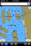
- It is the only app that keeps the charts in a course up orientation and rotates the display as your boat turns. The rotation is super fast too and will keep up with your boat.
- It uses the full resolution on the iPad which makes it a pretty big chartplotter. I'm excited about it because I saw it for myself today on real iPad hardware.
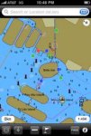
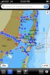
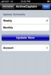
- It stores ALL of the data offline. So if you're looking for boat ramps in the boonies, you don't need any internet connection at all. Every marker, detail, and review is included. Press the Update button when you have an internet connection, and it synchronizes all of the new data onto your device since the last update from our server.
- Tide table are fully integrated - no need for another app for that. All tide calculations are offline too so no internet connection is needed tide predictions.
- All NOAA buoy stations are integrated as well showing the latest live reports from the NDBC buoys. This obviously requires an internet connection because the data is all live.
It's like 4 programs all integrated and combined into one app.
These are some good ideas - adding trailer shops, etc. Here's my question - is there a source that has a good starting list of these types of places? We've added about 15 categories now. What we found is that if we can seed the list with a good starting number of items, people are more apt to add their own items. Some of that might change in the future because we have a fair amount of other data now and people get the idea of what we're doing and see the value.Is the iPhone app done yet???")
The iPhone app....it's close. It has a week or so more development and then the Apple approval process. Here's some other things to tease you about it:
- Purchasing it allows it to work on both your iPhone and iPad (if you have one) at the same time. You don't need to purchase it twice if you have an iPad.
- It is the only app that keeps the charts in a course up orientation and rotates the display as your boat turns. The rotation is super fast too and will keep up with your boat.
- It uses the full resolution on the iPad which makes it a pretty big chartplotter. I'm excited about it because I saw it for myself today on real iPad hardware.
- It stores ALL of the data offline. So if you're looking for boat ramps in the boonies, you don't need any internet connection at all. Every marker, detail, and review is included. Press the Update button when you have an internet connection, and it synchronizes all of the new data onto your device since the last update from our server.
- Tide table are fully integrated - no need for another app for that. All tide calculations are offline too so no internet connection is needed tide predictions.
- All NOAA buoy stations are integrated as well showing the latest live reports from the NDBC buoys. This obviously requires an internet connection because the data is all live.
It's like 4 programs all integrated and combined into one app.