GPS/Chartplotter for Non fisherman

Nklpltd

Cadet
Joined
Sep 14, 2011
Messages
9
Hey guys i need some help.

I'm new to boating and haven't quite bought my first boat yet, still waiting for the right deal. I'm looking at a early 80's Sleekcraft Executive IB/OB.

The boat will be used for cruising, pulling skiers/tubes and camping trips to Lake Powell.

Right now i live in Northern Utah, so this boat will only be used on lakes in and around the state.

I plan on taking this boat to lakes that i've never been to before and want to be comfortable with my navigation on the water when i get there, and not destroy my hull when i try to beach or camp.

With many lakes around Utah, especially Lake Powell, the shores change every year. When cruising and hanging out at the lake, we like to beach the boat (friends boats) and eat lunch or hang out on the beach for a bit. So here is my dilemma. I don't ever plan on using this boat for fishing, but want good navigation on the water and good shore/shallow water imagery would be a great help.

From my research, i've gathered that to get the water imagery, i would need a FF/sounder correct?

Here are the models i've found from my research. Please help me narrow it down, or let me know if there is something i should consider.

Raymarine: A50D, A57D or A70D

Standard Horizon: CPF309i or CPN700i

Lowrance: Lowrance Elite 5 DSI Gold

Garmin: GPSMAP 546S or GPSMAP 720

Hummingbird: 898c SI Combo or 798CI HD

I've noticed that some have 3D/4D imagery which sounds pretty cool, but it seems like with my problem of going to lakes that shore lines frequently change, will defeat a pre programmed map shoreline correct? If this is the case, what would you guys recommend for a GPS/Chartplotter/FF that will give me current detailed shoreline shallow imagery?

Thanks for your help.

Jake
 

chriscraft254

Commander
Joined
Jun 4, 2011
Messages
2,445
Re: GPS/Chartplotter for Non fisherman

I am partial to the Lowrance products, because it is what I use. But any of the units you are considering will do the job. Yes you will need a transducer for any unit. The type of transducer will depend on what depths you read the most. Some are better for shallow versis deep.

May also take a look at the Lowrance hds-5 or hds-7insight. Combo plotter/fishfinders are nice to have. Your not going to find anything as far as a chartplotter that will give you changes in topography bases on low water or high water. If your looking for that kind of thing, you may want to look into a radar that will show you the shorelines as they are scanned in real time..
 

Nklpltd

Cadet
Joined
Sep 14, 2011
Messages
9
Re: GPS/Chartplotter for Non fisherman

I just added Hummingbird 798 and 898 to the list. I just saw they have downscan imaging, which seems exactly what i need. The Lowrance Elite 5 DSI also has this down can imaging.

Does anyone have any experience with this down scan type technology?
 

chriscraft254

Commander
Joined
Jun 4, 2011
Messages
2,445
Re: GPS/Chartplotter for Non fisherman

The lowrance hds-5, hd-7 and the larger models all have the option of downscan. I will say, the hummingbirds are more popular in your area and the service is suppose to be very good.

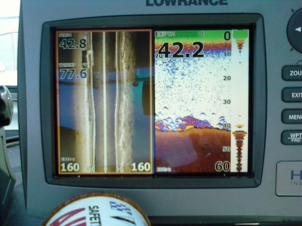
I have downscan/sidescan. It will help you identify/find structure but won't do much more than your depthfinder will do as far as showing you bottom. It gives you a sidescan or a downscan. You can adjust it to scan different sides,both sides or down. Can't see the sidescan as being an advantage for navigation any more than a regular depth finder, it is more for fisherman who want to see structures better under water. Here is a couple pics of sidescan/downscan.
Newboatpics1160.jpg

Newboatpics1169.jpg


I just added Hummingbird 798 and 898 to the list. I just saw they have downscan imaging, which seems exactly what i need. The Lowrance Elite 5 DSI also has this down can imaging.

Does anyone have any experience with this down scan type technology?
 

Nklpltd

Cadet
Joined
Sep 14, 2011
Messages
9
Re: GPS/Chartplotter for Non fisherman

But would it show me what's under my boat at less than 10 feet? I know that a lot of lakes around where i live, they've redone the slopes leading up to the beach areas and some areas have pretty good size rocks under the surface and i really don't want to scrape my hull along them. That's what i'm thinking the down imaging would be good for. At more than 10 feet i am only interested in the unit as a chart plotter/gps.
 

chriscraft254

Commander
Joined
Jun 4, 2011
Messages
2,445
Re: GPS/Chartplotter for Non fisherman

I suppose it could help if you were to use the sidescan option on it and scan the shoreline before approaching. Keep in mind that this is pretty good technology but its not fail safe stuff. Your knowledge of the lake, and taking it slow while beaching is key. also, I'm not sure the sidescan is going to scan something that shallow because even on sidescan, it is still scaning downward at an angle.
 

Nklpltd

Cadet
Joined
Sep 14, 2011
Messages
9
Re: GPS/Chartplotter for Non fisherman

I totally agree, common sense when approaching the shore goes A LONG WAY! But anything that can give me an idea of what's possibly coming is worth having in my opinion. It's just what is the best tool to own.
 

chriscraft254

Commander
Joined
Jun 4, 2011
Messages
2,445
Re: GPS/Chartplotter for Non fisherman

Keep in mind that transducers are mounted either by a thru hull or at the stern of your boat, so knowing exactly where a structure might be is still a little bit of guess work. These are made to show you structure so you can fish them, not to show you oncoming structure or things in front of the boat. Like I said though, the side scan may work. I will test it out this week along side a beach here and let you know how shallow it will scan.
 

chriscraft254

Commander
Joined
Jun 4, 2011
Messages
2,445
Re: GPS/Chartplotter for Non fisherman

Np Good luck with your selection. I think the hummingbird comes with sidescan, where as the lowrance doesn't, it is an option. Not sure what the cost difference is.
Thanks. That would help a lot.
 

dingbat

Supreme Mariner
Joined
Nov 20, 2001
Messages
15,472
Re: GPS/Chartplotter for Non fisherman

As noted, tranducuers tell you how much water is at the back of the boat. Your sounder could read 10' and the bow of the boat is sitting on the beach. No depth finder is a replacement for local knowlwdge.

You have to be moving very slowly for down and side scan to work.

Most maps have not been update in the past 20-25 years.
 

Silvertip

Supreme Mariner
Joined
Sep 22, 2003
Messages
28,758
Re: GPS/Chartplotter for Non fisherman

Sounders present a "cone" so the deeper the water, the larger the area being pinged. At speed, you will definitely hit whatever is in your way at least one boat length before the transducer pings that object and translates what it sees and displays the image. Nothing can show you a changing shoreline/bottom structure until YOU pass over it and see the image. Once you learn how to use a standard fish finder (actually a locator as they can't actually "find fish") you can use even the cheapest locator for navigation. They work great for following narrow channels or ridge liines.
 

ssobol

Chief Petty Officer
Joined
Sep 3, 2010
Messages
503
Re: GPS/Chartplotter for Non fisherman

There are forward looking sonar units. Mostly made for larger boats and yachts. I saw a video on-line showing one in operation, but I can't remember the name. I think that the forward looking units are a lot more expensive and may require multiple transducers.

The forward view is limited (100 yards or so), but this is probably good enough for you.

I just take it slow when approaching shallow water. If the water is reasonably clear I have someone on look-out at the bow. If it is murky you have to watch for surface disturbances to the water flow. After some experience you can usually spot potential obstacles this way.
 

Woodnaut

Chief Petty Officer
Joined
Jul 4, 2007
Messages
634
Re: GPS/Chartplotter for Non fisherman

I installed a Garmin 546s Chartplotter/Sounder last winter. It's awesome. It also interfaces to my VHF radio for automated distress call plotting (which is a feature found on many units these days). For my use - along the coast and in shallow Texas bays - it works great. I thought that the 546 was for coastal areas, and a slightly different model number was the same unit but loaded with inland lake info. (Maybe I dreamed that, but check out the Garmin web site.) For me it's the right machine.
 

Star

Chief Petty Officer
Joined
Sep 21, 2010
Messages
481
Re: GPS/Chartplotter for Non fisherman

I agree that you will get into trouble trusting water depths on any preprogramed GPS/Map units. Their information is generally good but don't count on it. I purchased a Garmin GPS/MAP 398 five years ago. I was very happy with all the lakes they detail with many boat ramp locations on the larger lakes. I use this unit on long island sound and lakes in the upper New York State. It isn't the best finder but it packs many features that I use every time I go out. The unit is very durable and their support and updates are excellent. I use TWO sets of eyes when I know I am entering
shallow water. Good Luck on your choice.
 

Nklpltd

Cadet
Joined
Sep 14, 2011
Messages
9
Re: GPS/Chartplotter for Non fisherman

Thanks for the replies... i can see your point(s). There is nothing better than a good eye and sensible speed. I'm just looking for something to aid in that search.

As noted, tranducuers tell you how much water is at the back of the boat. Your sounder could read 10' and the bow of the boat is sitting on the beach. No depth finder is a replacement for local knowlwdge.

This is a great point. Is there a way to mount 2 transducers, one in the front and rear?

when we're out with friends, then the extra set(s) of eyes will definitely help, but when i'm only with the wife... i'm not quite sure i can trust her sense of depth or speed. I love her to death, but for example when i'm backing up a trailer, i'll hit the trailer and she'll still be telling me to keep backing up.
 

dave11

Lieutenant Junior Grade
Joined
Dec 2, 2007
Messages
1,195
Re: GPS/Chartplotter for Non fisherman

I have a networked Raymarine C70 with VHF and radar on my big boat and a Garmin 740s on the little one. I much prefer the garmin.
 

Justin007

Recruit
Joined
Oct 6, 2011
Messages
5
Re: GPS/Chartplotter for Non fisherman

Make sure you take a look at the cartography as well. If you are spending a lot of time on lakes, you will want to make sure your charts cover the lakes. Most plotters use either cmap or navionics chips. I would check out both of their web sites to make sure their charts cover the area you want to go. That way, you can at least eliminate that factor!
 
Top