Navionics APP - iPhone

southkogs

Moderator
Staff member
Joined
Jul 7, 2010
Messages
14,935
Marine_Logo_600x600pixels.jpg

I just wound up using this app more substantially than usual this week and thought I'd do a quick write-up on it. It wasn't expensive, and certainly is not a tool to challenge the bigger systems. But for what I do inland, and recently on the ICW it worked very well.

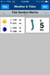
I've used the app in the past to navigate some channels here in TN where I don't know the waters all that well. The depth charts are pretty accurate, and I can mark certain points and keep data with regards to those points. For example, the marina I launch at most here in the Nashville area displays as so:
IMG_0770.jpg

Showing me some weather, winds, sunup and sundown. If we had tides, or significant currents in these areas they would display below wind and sun showing times and levels or flows.
 

southkogs

Moderator
Staff member
Joined
Jul 7, 2010
Messages
14,935
The app is available for both Android and IOS, and it will run on a tablet if you have GPS on it. You would have to download your maps while connected to WIFI or cell connection.

I used the app for a couple of different runs I did recently in Naples, FL. This is one I routed from our island house down to Marco Island:
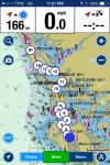
IMG_0768.jpg

It's very easy to set the route even on my iPhone 4. You hit the ROUTE button on the bottom, then press and hold your waypoints until they appear. Once I completed the run down to Marco Island, I simply selected the route, and reversed it for the trip home (displayed above). The blue dot is the starting point, and the checkered flag is at the end of the route.

The arrow button in the bottom left is the button to track your boat on the route, and the zoom control in the upper right allows you to see as much or little of the area as you like. I've got it zoomed WAY out for the screen shot above. The GOVT button allows you to change the map displays. I prefer the Navionics map, but used the GOVT map on this run. There is also an option to connect a sounder to the software as well. I don't have one, so I'm not sure how it works.

If you notice at the top, it will show you distance from your next way point (I took the screen shot after we were off the island), current speed and ETA (which I didn't think worked all that well ... it was constantly changing as we were moving along).

If you note the "pushpin" markers on the screen: the one you see close to where is says "Tarpon Bay" is the fuel dock I found out about when I got to Marco. The marina I originally planned on didn't have dock fuel as I was led to believe it would, so I had to divert over (it wasn't far). I have a similar marker for where the cars were parked and for the pier where our house was.

The photo icon allows you to upload photos into the system - I THINK they're posted in Navionics maps for all to see, but I'm not certain of that as I haven't used it yet. But you can make notes and images for things you find in your area that you want marked.

 

southkogs

Moderator
Staff member
Joined
Jul 7, 2010
Messages
14,935
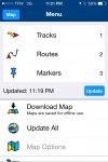
Menus are pretty easy to figure out:
IMG_0767.jpg

Here you can see I have one track stored (the track from Naples to the Island), two routes (the route from Naples to the Island, and from the Island down to Marco) and 3 Markers (the house, the cars and the Winn Dixie). Map options are just below that.

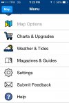
IMG_0769.jpg

There are some upgrades you can purchase (though from what I can tell many are tough to use on smaller screens), the weather and tides button (which shows you the screen in my earlier post), settings and magazine options.
 

southkogs

Moderator
Staff member
Joined
Jul 7, 2010
Messages
14,935
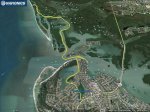
Once you've completed a track, you can send it via email to yourself and view it in any mapping software. I pulled up the track:


Sent it to myself and then viewed it in Google Earth:
Marco Trip.jpg

You can see my "diversion" over to the fuel dock coming off Collier Bay.
 

southkogs

Moderator
Staff member
Joined
Jul 7, 2010
Messages
14,935
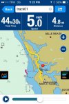
The actual track itself can be played back with all of the trip data displayed:
IMG_0761.jpg

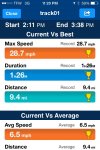
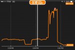
And the system will give you all kinds of details about the trip:
IMG_0759.jpg

IMG_0758.jpg
 

southkogs

Moderator
Staff member
Joined
Jul 7, 2010
Messages
14,935
If you enter the information for your boat, you can even calculate fuel burn and ETA on a trip based on average cruise speed. Both of those two features are still kinda' rough in my opinion.

There's a few other things it'll do for you and different ways to display with it.

Overall, it's a pretty sharp app.
 

Scott Danforth

Grumpy Vintage Moderator still playing with boats
Staff member
Joined
Jul 23, 2011
Messages
49,893
my problem is the phone isnt bright enough to see in FL sunshine.
 

southkogs

Moderator
Staff member
Joined
Jul 7, 2010
Messages
14,935
my problem is the phone isnt bright enough to see in FL sunshine.
I had enough cloud cover that I was okay. I also had my phone kinda' hanging with the dash board (my wallet / phone cover has an integrated - sort of - stand), so it wasn't directly angled to the sun. In the bright spots I did hit while down around Marco Island, between angles and the bimini I could see fine.

Here in TN, I've used the app more in the dark than during the day. The few times I've used it during the day, I either just needed a glance to see I was going the right way and did so in a shadow, or have one of the kids call the track out to me. But you are correct, sun on the screen can make it tough to see.
 

REN3G8

Petty Officer 3rd Class
Joined
Mar 13, 2017
Messages
97
Just wanted to say this is an awesome app, works great on my LG G6, had it on my older Acer A100 tablet but the GPS died on it.

Definitely recommended as it got me out of trouble with rocks and shallow spots a few times already, that I wouldn't have know about with the fish finder alone.
 

Coxwain

Seaman Apprentice
Joined
Aug 14, 2017
Messages
46
Are you better to get an iPad mini or cheaper android and attach a stand to it than get an expensive depthfinder?

Probably $200 could get you a great tablet to mount on your deck.
 

REN3G8

Petty Officer 3rd Class
Joined
Mar 13, 2017
Messages
97
Coxwain I'd say yes... it worked with my old (2012) Acer A100 7" tablet , but the GPS receiver died on it on my second try. Worked great on the first outing, but I found the screen was hard to see due to the sun. I have put together a special mount built from a combination of a phone mount suction base, frankensteined with the stand from a headrest tablet mount, this held pretty good on the boat windshield.

Maybe research and see what newer or older tablets are good in the sun, I may eventually do that and pickup a 7" tablet again... for now my LG G6 does great in the boat as everything. (phone, marine navi, and music player)
 
Top